Studley (Warwickshire)
| Studley | |||
|---|---|---|---|
|
|||
| Coordinates | 52 ° 16 ′ N , 1 ° 53 ′ W | ||
|
|
|||
| Residents | 6624 | ||
| administration | |||
| Post town | STUDLEY | ||
| ZIP code section | B80 | ||
| prefix | 01527 | ||
| Part of the country | England | ||
| region | West Midlands | ||
| Shire county | Warwickshire | ||
| District | Stratford-on-Avon | ||
| ONS code | SP075635 | ||
| Website: studleyparishcouncil.org.uk | |||
Studley is a village in the English county of Warwickshire . It borders directly on Redditch in Worcestershire to the northwest .
Birmingham to the north, Warwick to the east, Stratford-upon-Avon to the south and Worcester to the west are each 20 to 30 kilometers away .
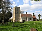
In the village is the Church of the Nativity of the Blessed Virgin Mary (St. Mary's Nativity ), the Little Zoar Chapel of the strict Baptists and one kilometer further south the historic church building St Leonard .
From 1898 to 1969 the place housed the Studley Horticultural & Agricultural College for Women , a housekeeping and horticultural school that resided in Studley Castle from 1903.
Personalities
- Dion Fortune (1890-1946), occultist
- Andy Smith (* 1967), darts player
Web links
Commons : Studley - collection of images, videos and audio files


