Fall cock
| Fall cock | ||
|---|---|---|
|
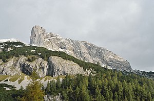
The Sturzhahn seen from the Tauplitzalm |
||
| height | 2028 m above sea level A. | |
| location | Tauplitz , Styria | |
| Mountains | Dead Mountains | |
| Coordinates | 47 ° 36 '28 " N , 14 ° 1' 26" E | |
|
|
||
| rock | Banked Dachstein limestone | |
|
Fall cockerel |
||
The Sturzhahn , also Traglsturz or Traglhahn , is a 2028 m above sea level. A. high mountain in the Dead Mountains in Styria on the edge of the Tauplitzalm . The Sturzhahn is actually the southwest shoulder of the Großer Tragl .
First ascents
Heinrich Harrer and Kurt Wallenfells first climbed the 200 meter high west wall of the Sturzhahn in 1935 . The Sturzhahn is now also considered to be the former climbing mountain Harrers, who spent his holidays from 1933 to 1936 as the host of the nearby Grazer Hütte .
Climbs
The Sturzhahn is climbed from the Tauplitzalm or Tauplitz , the path also leads past the Steirersee .
Individual evidence
- ^ Federal Office for Metrology and Surveying Austria: Austrian Map online (Austrian map 1: 50,000) .
- ↑ Grazerhütte website , viewed on October 11, 2017
- ^ Strunz, Gunnar: Styria, the green heart of Austria . 4th updated edition. Berlin 2017, ISBN 3-89794-340-9 , pp. 81 .
Web links
Commons : Sturzhahn - collection of images, videos and audio files


