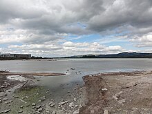
Sulfur Bay
The Sulfur Bay is the southernmost foothills of Lake Rotorua on New Zealand's North Island . In it are the small islands of Timanga Island and Moutere Island .
The bay south of the line from Motutara Point to the east has been protected as a Sulfur Bay Wildlife Refuge since 1967 . The area had been under protection as a game reserve for native and imported game birds since 1904. There are Maori gulls , red-billed gulls , Dominican gulls , cormorants , magpie shots and double-banded plovers .
The area of the bay is geothermally active, so the cloudy, warm water is acidic and poor in oxygen. It contains little food, so many seabirds visit other parts of the lake for food every day.
Hydrogen sulfide gas rises from the bottom of the bay, causing the water to become cloudy due to sulfur particles in the water and to the deposition of yellow and black sulfur crystals. There is an area of mud pots , hot springs and fumaroles on the western coast of the bay . These are covered by a sintered layer that was deposited by alkaline sources when the water level was higher.
The largest mud pot is "Cameron's Laughing Gas Pool". This pool, also known as the White Sulfur Bath , was used as a medicinal bath by European settlers in the late 19th century and was therefore possibly the first commercial bath in the area, which is now characterized by spa tourism. It was leased from the Okiwi Ngata to hotelier James Morrison for £ 5 a year before 1879 , but was later abandoned due to financial disputes. Rising hydrogen sulfide and carbon dioxide gas caused the visitors to have similar uncontrolled fits of laughter as with laughing gas . However, the bath was dangerous because of the risk of unconsciousness, so you had to approach the pool from the side facing the wind. The water was later pumped into a nearby wooden bathing pool.
Individual evidence
Coordinates: 38 ° 8 ′ 9 ″ S , 176 ° 15 ′ 45 ″ O


