Sumbar
|
Sumbar Sari-su, Sara-su, Ṣáríṣú |
||
|
|
||
| Data | ||
| location | Turkmenistan , Iran | |
| River system | Atrak | |
| Drain over | Atrak → Caspian Sea | |
| Confluence of |
Dainessu and Kulunsu 38 ° 11 '24 " N , 57 ° 0' 9" O |
|
| muzzle |
Atrak coordinates: 37 ° 59 ′ 28 " N , 55 ° 16 ′ 26" E 37 ° 59 ′ 28 " N , 55 ° 16 ′ 26" E
|
|
| length | 245 km | |
| Catchment area | approx. 8300 km² | |
| Left tributaries | Tschandyr | |
|
The course of the Sumbar in the border area between Iran and Turkmenistan |
||
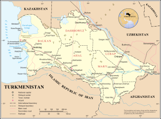
The Sumbar ( Persian سومبار; also Sari-su, Sara-su, Ṣáríṣú) is a right tributary of the Atrak in Turkmenistan and a border river to Iran in the catchment area of the Caspian Sea .
The Sumbar arises at the confluence of the Dainessu and Kulunsu rivers in the Kopet-Dag Mountains on the border between Turkmenistan and the Iranian province of North Khorasan . It flows in a west-north-westerly direction and forms the state border over a distance of about 20 km. It then flows north for about 15 km before changing its direction to the west and later to the west-southwest. The Tschandyr (in Iran also Jschergelan ), the most important tributary of the Sumbar, flows into the river on the left. The Sumbar reaches the state border with Iran again and flows along it until it flows into the Atrak. The Iranian province of Golestan is located on the southern bank of the river . The lower reaches of the Sumbar fall dry for 2–5 months a year.
The Sumbar has a length of 245 km. Its catchment area covers approximately 8300 km².
Some of the river water is diverted for irrigation purposes . Sub-tropical horticulture is practiced in the Sumbar valley.
The name Sari-su means "yellow water" in the Turkic languages .
