Susanne position
The Susanne position was a defensive position of the German armed forces in World War II .
geography
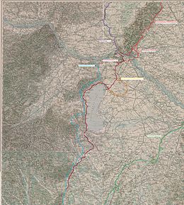
The Susanne position began in the fortress sector of Sillein (Žilina) and stretched over the mountains of central Slovakia via Banowitz (Bánovce nad Bebravou) to Neutra in the direction of Neuhäusel along the east side of the river Waag across the then Slovak / Hungarian border via Komorn (Komárom) Raab (Győr). From there it followed the course of the river via Kotenburg (Sarvar) always along the river until it reached the position system of the southeast wall again at Sankt Gotthard an der Raab (Szentgotthárd).
description
The Susanne position was set up by the high command of the Wehrmacht towards the end of the Second World War on the southeast wall or the Reich protection position against the advancing units of the Red Army . This fortified gun emplacement on the south-eastern border of the German Empire was planned as an alternative position in the event that the German positions in central Hungary fell. As with the south-east wall, entire parts of the Susanne position remained in the planning stage. The sections between Sillein (Žilina) and Banowitz (Bánovce nad Bebravou) and between Raab and Kotenburg (Sarvar) were never fully completed.
The Susanne position was completed in 1944 and overrun by Red Army troops in the spring of 1945 .
Individual evidence
- ^ Manfried Rauchsteiner , Manfred Litscher (ed.): The Army History Museum in Vienna. Graz, Vienna 2000
