Széll Kálmán tér
The Széll Kálmán tér (from 1951 to 2011 Moszkva tér ) is a public square in Budapest . It is an important transport hub in Buda and connects line 2 of the Budapest Metró with numerous tram and bus lines. Among other things, lines 4 and 6, which serve Nagykörút , end here .
After the square was unnamed until 1929, it was named after the former Prime Minister Kálmán Széll . After the Second World War it was called Sztalin tér for a short time . In 1951, according to other sources as early as 1946, the square was named Moszkva tér in honor of Moscow before it was renamed Széll Kálmán tér again in 2011 by the Budapest city council with the votes of Fidesz and Jobbik .
location
The square is located in the north of Buda , about one and a half kilometers from the nearest Danube crossing, the Margaret Bridge. A large part of the square is in the II. District , it also borders on the XII. and I. District . At Széll Kálmán tér the bourgeois areas of Krisztinaváros and Víziváros, the villa district of Rózsadomb , the touristic castle district and the upscale districts of the Buda Hills come together. Due to its central location, the square is one of the most popular meeting places in Buda.
history
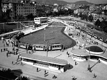
At the end of the 17th century, a clay pit and later a brickworks were built on the site of today's Széll Kálmán tér . Clay mining was abandoned when, at the end of the 19th century, a city ring around downtown Buda, today's Margit körút / Krisztina körút , was built along the west side of the square . On the site of the former mine, the Buda Athletics Club then built an ice rink and later a sports field with a clubhouse. In the 1930s, tram lines ran from Széll Kálmán tér in the direction of Hűvösvölgy and Zugliget , which were popular weekend excursions with the city's population.
During the Second World War , the square was expanded into a tram junction in 1942 when a lack of rubber affected car traffic. The tracks at Széll Kálmán tér were laid out for trams and freight trains in order to be able to transport goods from Déli pályaudvár to Óbuda in the event of the Northern Railway Bridge being blown up . During this time, the tunnel at the southern end of the square was also built, which replaced a previously existing ramp for trams. After the end of the war, the route was used, among other things, to transport coal from Dorog . The Lokomotiv- und Waggonfabrik Ganz transported goods there until 1964 .
In 1972, the Metró Budapest (M2) line opened at Moszkva tér station , for which a large entrance building was built on the square. The new metro stop increased the importance of the space for local transport: for many residents of the districts and suburbs in the Buda Mountains , it was the last inner-city stop.
Renovation 2015/16
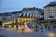
After the square had undergone major renovation for the last time in 1972 when the M2 was opened and the tracks had been rebuilt in 1990, the Budapest Transport Company ( Budapesti Közlekedési Központ , BKK) planned a complete renovation of the Széll Kálmán tér from 2011 with an investment volume of 3 billion forints . The construction work lasted from January 2015 to May 2016 and cost a total of 5.3 billion forints. The streets, tracks and supply lines were completely renewed and partially relocated, access to metro line 2 was renovated, new bus shelters for the tram were built and cycle paths were built. In addition, new green areas and LED lighting were created to trace the paths of the pedestrians at night.
The opposition party Jobbik filed a criminal complaint in connection with the increase in the cost of the renovation in May 2016 for "misappropriating public funds" and argued that the renovation was "optical tuning" that did not improve traffic conditions. The web portal Guiding Architects criticized the fact that the stops of lines 4 and 6 had not been relocated and were still on one of the busiest streets in Budapest.
Web links
- Széll Kálmán tér teljes reconstruction. Official website of the BKK on the conversion (Hungarian)
Individual evidence
- ^ A b c d Judit Bodnár: Assembling the Square: Social Transformation in Public Space and the Broken Mirage of the Second Economy in Postsocialist Budapest . In: Slavic Review . tape 57 , no. 3 , 1998, p. 489-515 , doi : 10.2307 / 2500709 .
- ^ Széll Kálmán tér lett a Moszkva térből. In: hvg.hu , April 27, 2011, accessed on January 12, 2017
- ^ A b Zoltán Ádám Németh, András Székács: The Moszkva Tér Tram Junction. In: Villamosok.hu , accessed January 12, 2017
- ↑ a b Katrin Holtz: Finally handed over to the public. In: Budapester Zeitung , May 21, 2016, accessed on January 12, 2017
- ^ Facelift for the Szell-Kálmán Square in Budapest. In: Guiding Architects , May 6, 2016, accessed January 12, 2017
Coordinates: 47 ° 30 '25.9 " N , 19 ° 1' 29.7" E


