Hegyvidék
|
Hegyvidék Highlands XII. Budapest district |
|||
|
|||
| Basic data | |||
|---|---|---|---|
| State : | Hungary | ||
| Region : | Central Hungary | ||
| County : | Budapest | ||
| Coordinates : | 47 ° 30 ′ N , 19 ° 0 ′ E | ||
| Area : | 26.67 km² | ||
| Residents : | 55,922 (Jan. 1, 2011) | ||
| Population density : | 2,097 inhabitants per km² | ||
| Postal code : | 1121-1126 | ||
| KSH kódja: | 24697 | ||
| Structure and administration (status: 2014) | |||
| Community type : | district | ||
| Structure : | Districts
|
||
| Mayor : | Zoltán Pokorni ( Fidesz ) | ||
| Postal address : | Böszörményi út 23-25 1126 Budapest |
||
| Website : | |||
| (Source: A Magyar Köztársaság helységnévkönyve 2011. január 1st at Központi statisztikai hivatal ) | |||
As Hegyvidék the twelfth district is Budapest (XII. District) called. The district is located in the center of Buda in a mountainous area. A large part of the area is forest.
Location and dates
In the north of Hegyvidék (Bergland) is the 2nd district , in the east of the 1st district and in the south it borders on the 11th district . The western border is also the city limit of Budapest. Neighboring towns are Budakeszi and Budaörs . With around 60,000 inhabitants, Hegyvidék is in 18th place compared to the other 23 districts.
The 12th district is divided into the following areas: Budakeszierdő (partial), Csillebérc , Farkasrét , Farkasvölgy , Istenhegy , Jánoshegy , Kissvábhegy , Krisztinaváros (partial), Kútvölgy , Magasút , Mártonhegy , Németvölgy , Orbánhegy , Sashegy (partial), Svábhegy , Széchenyihegy , Virányos and Zugliget .
history
The 12th district has existed since 1930, when the then 10 districts of the city were restructured and additional districts were added. Until then, the Hegyvidék was part of the 1st district . The history of the district is closely linked to the smaller settlements, homesteads, forest and vineyard holdings that were under the administration of Buda. The Krisztinaváros (“Christian City ”) was formed between the Castle Hill and the Buda Mountains , in the valley formed by the Ördögárok (“Devil's Trench”). It extends from Pasarét ("Sauwiesen") to Tabán ("Raitzenstadt"), which is today the 1st and. 2nd district belong. The area at the western foot of the castle hill, where the Vérmező ("Blood Field") park is located today , was the so-called "Glacis" in the 18th century. This area belonged to the protective belt around the castle and was under military control. The fact that no buildings were allowed to be erected there hindered the expansion of the city in this direction for a long time. In 1920 the ditch was lined, trees felled and the area was released for building. The art patron Albrecht Kasimir began to parcel out the area in 1772 at the instigation of his wife Maria Christina . Since then it has officially been called Krisztinaváros. One of the five parts that make up the Krisztinaváros is Városmajor (short: "Major", German: "Stadt-Meierhof"), in today's 12th district. The park was founded in 1787 by Joseph II , after whom it is also named. The Ördögárok flows through the green area. At the northern end is the lower terminus of the rack railway .
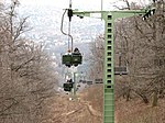
The northern part of the district is characterized by the Hunyad peak and the valleys sloping to the south and north. Most of it belonged to the Buda Carmelites until the end of the 18th century . In the 18th and 19th centuries the name of the northern part was Sauwinkel, later Auwinkel. Only in the course of the Magyarization of German names did the name Pasarét come into use. According to one theory, the name goes back to the last pasha of Buda, Abdulrahman. Another explanation is based on the fact that the area next to the Ördögárok was called "pasa" in Serbian and "Ried" in German. In 1847, the poet and royal adviser Gábor Döbrentei named the northern narrow section of the valley Zugliget as part of the Magyarization ( Dűlőkeresztelő ) and he named the southern part towards Krisztinaváros Virányos. There is also the old cemetery of Víziváros , where the Hungarian Jacobin leader Ignác Martinovics and his followers executed on the Vérmező were buried in 1795. On the south side of the Hunyad lies Kútvölgy, which was previously called Brunnthal. In the area, which was still overgrown by dense forests in the 19th century, there were only a few orchards and fields of isolated farms. Zugliget, where there used to be a lot of wild boar , was once part of Matthias Corvinus' hunting ground . Hence the German name Sauwiesen, which is also used in the name of the Disznófő ("pig's head") source. From the second half of the 19th century, especially after the destruction of the vineyards, the development of this area began. A significant part of the district has remained an undeveloped destination to this day. The Zugligeti chair lift, completed in 1970, leads there .
The valleys and hills between the Svábhegy ("Swabian Mountain") and the Széchenyi Mountain are deeper and less developed. There are the mountains Mártonhegy, Istenhegy, Kis-Svábhegy and Orbánhegy. Royal hunting grounds were formerly located here, and later the property of Buda citizens. At the end of the 17th century, at the time of the reconquest of Buda, this area was also the scene of the city's history. For strategic reasons there were army positions there. In the 19th century the area was important as a wine-growing area. In the second half of the 19th century , more and more villas were built there, especially at the instigation of Mór Jókai . Further development and increasing tourism led to the construction of the cog railway, which opened in 1974. After the Second World War , the Budapest Children's Railway was built on Széchenyi Hill .
The most famous part of the 12th district is the crown of the Buda Mountains Jánoshegy, Svábhegy, Széchenyi-hegy, Csilleberc and the Budakeszi Forest . There are a variety of hiking trails and destinations as well as ski slopes. Jánoshegy is part of the Duna-Ipoly National Park . At 528.16 m it is the highest point in Budapest. The Erzsébet-kilátó ("Elisabeth Lookout Tower") is located on the summit . The Svábhegy in the center of the Buda Mountains has an average height of 480 m. The dolomite rock is connected to the Svábhegy in the north. The mountain got its name after the liberation from Turkish rule when German artillery pieces were stationed there. In the 50s of the 19th century, the mountains became more and more popular as a holiday destination and an elegant residential area was created. The mountain with the largest area is Nyék-hegy to the southeast, which was so named in 1860. Until the end of the 19th century there were only a few holiday homes there. Today these can be found up to the top of the mountain. Behind the mountain range is Csillebérc, a child and youth center. On the southern flank of the mountain range are several valleys, Németvölgy ("Deutschenthal"), Farkasvölgy ("Wolfstal") and Irhás-árok ("Lederergraben") as well as the Farkasrét plateau ("Wolfswiese"), on which the cemetery of the same name is located . Of the districts, Németvölgy is the largest. The name Deutschenthal has been used since the 17th century because German troops were staying there to fight the Turks. The Hungarian translation has been in use since 1847. Most of the fields and vineyards emerged in the second half of the 19th century. In 1884 the sports hospital Erzsébet Kórháza ("Elisabeth Hospital") of the Hungarian Red Cross was opened. At the turn of the century, the industrial company Magyar Optikai Művek (MOM) settled there . In 1951 the MOM cultural center was built under Soviet leadership.
Local politics
From 1990 to 2006
After the first municipal elections in 1990, Gábor Sebes ( SZDSZ ) became mayor. In the next elections in 1994, a coalition of MDF and KDNP emerged. Thereupon István Udvardy-Nagy became mayor of the conservative government. These majorities were also confirmed in the subsequent elections, but György Mitnyan moved from 1998 to 2006 to the office of mayor.
Since 2006
Since the election on October 1, 2006, the municipal council has 28 members. The mayor, who also heads the municipal council, has since been Zoltán Pokorni ( Hungarian Citizens' Union ). In the 12th district, the joint candidates from Fidesz and KDNP emerged as the election winners without exception. The representatives of the other parties MDF, MSZP and SZDSZ were elected via compensation lists.
| Mayoral candidate | Political party | Votes received | Result in percent |
|---|---|---|---|
| Zoltán Pokorni | Fidesz-KDNP | 20,073 | 59.55% |
| Norbert Élő | MSZP | 10,321 | 30.62% |
| Klára Ungár | SZDSZ | 3,312 | 9.83% |
Elected representatives according to list membership:
| list | representatives | Composition of the municipal council | ||||||||||||||||
|---|---|---|---|---|---|---|---|---|---|---|---|---|---|---|---|---|---|---|
| Fidesz-KDNP | 16 | |||||||||||||||||
| MSZP | 6th | |||||||||||||||||
| SZDSZ | 4th | |||||||||||||||||
| MDF | 1 | |||||||||||||||||
Culture
- Music school: Solti György Zeneiskola [1]
- Art school THÉBA Művészeti Szakközépiskola [2]
- Cultural center MOM
Attractions

- Barabás villa
- Budapest Congress Center (Budapest Kongresszusi Központ)
- Erzsébet-kilátó
- Normafa
- Farkasréti temető , cemetery
- Óra villa
- Plebane Church of the Sacred Heart in Városmajor
- Gizi Bajor Drama Museum
Partnerships
The district has partnerships with the Belgian municipality of Watermael-Boitsfort and with the Romanian city of Odorheiu Secuiesc .


