
Kispest
|
Kispest Klein-Pest XIX. Budapest district |
|||
|
|||
| Basic data | |||
|---|---|---|---|
| State : | Hungary | ||
| Region : | Central Hungary | ||
| County : | Budapest | ||
| Coordinates : | 47 ° 27 ' N , 19 ° 8' E | ||
| Area : | 9.38 km² | ||
| Residents : | 62,031 (Jan. 1, 2011) | ||
| Population density : | 6,613 inhabitants per km² | ||
| Postal code : | 1191-1196 | ||
| KSH kódja: | 04011 | ||
| Structure and administration (status: 2014) | |||
| Community type : | district | ||
| Structure : | Districts
|
||
| Mayor : | Péter Gajda ( MSZP ) | ||
| Postal address : | Városház tér 18-20 1195 Budapest |
||
| Website : | |||
| (Source: A Magyar Köztársaság helységnévkönyve 2011. január 1st at Központi statisztikai hivatal ) | |||


Kispest ("Little Pest") is the name of the nineteenth district (XIXth district) in Budapest . It was created on January 1st 1950 with the connection of the previously independent town of Kispest . At the same time, it is the name of the larger of the two districts that make up the district.
Location and dates
Kispest borders in the north on the 10th district, in the east on the 18th, in the south on the 23rd and in the west on the 9th and 20th district. Around four percent of Budapest's 1,696,128 residents live there. The current mayor is Péter Gajda from the Hungarian Socialist Party.
history
Until the 19th century
The area was settled before the time of the conquest . For example, traces of Avar settlements have been found. At the time of the Mongol storm, the settlements were destroyed. After that, the area served as a royal hunting ground for centuries, for example under Matthias Corvinus . In 1723 the area called Szentlőrinc puszta came into the possession of Antal Grassalkovich I , whose name was associated with the building of a chapel. After the Grassalkovich family died out, the owners of the area changed several times.
Until the First World War

In 1850 the area was divided into parcels. Then the engineer and ministerial advisor Károly Herich, the engineer József Egger and the lawyer Lajos Rózsa bought the land. With the Colonie-Klein-Pest , founded in 1869 , they were able to increase the value of the area. In 1871 the small community Kispest was founded.
In 1880 the population was 1,800 people of different nationalities. Kispest experienced a boom during the industrial revolution. This development was not slowed down when Pestszentlőrinc was separated from Kispest in 1909. A year later the population reached 30,000. In 1911, Kispest became the seat of the district government ( járási székhely ). This subdivision of counties , which no longer exists today, included the places Erzsébetfalva, Csepel, Soroksár, Pestszentlőrinc and Dunaharaszti.
In 1908, Prime Minister Sándor Wekerle initiated the construction of the garden city Wekerletelep , which was named after him , after the Sárkány family had bought the area with state funds. The Wekerletelep is an example of urban development in the 20th century and offered new living space for thousands of people. The planning of the area followed regular geometric shapes. Wekerletelep was originally intended as a residential area for workers, but ultimately only members of the middle class were allowed to settle there. The gate at the geometrically highlighted Fő tér (“main square”) was designed by Károly Kós , an architect from Transylvania and has stylistic features from his homeland.
Between the world wars
The industrialization of the area, for example through the factories Hofherr-Schrantz and Hungária-Jacquard, led to increased social tensions , especially at the end of the First World War .
In 1920 the population rose to 50,000, 92% of whom spoke Hungarian. On November 15, 1921 it was decided that Kispest receives the status of a city ( rendezett tanácsú város ). The founding meeting took place on July 22, 1922. The first mayor was Dr. Gyula Válya, who was succeeded by József Molnár in 1930.
The city's increasing debt could not be slowed until 1936. During the Second World War , especially in 1943 and 1944, area bombing caused severe damage.
After the Second World War
After the war , Miklós Petri, then Gyula Barei, became mayor. The mayor elected in 1947 was the last to hold this office. On January 1, 1950, Rezső Nyers became the council chairman of Kispest, which has since been the 19th district of Budapest.
Showrooms
- Kispesti Helytörténeti Gyűjtemény ( Fő utca 38 ): The exhibition provides information on the history of Kispest from its founding as an independent municipality until 1950.
- Nagy Balogh János Kiállítóterem ( Ady Endre út 57 )
Sports
The football club of Kispest is the Budapest Honvéd FC (formerly Kispesti AC , Budapesti Honvéd or Kispest-Honvéd ). After Fradi , MTK and Újpest , the club is one of the most successful in the country. In addition, the football player Ferenc Puskás was born in Kispest. He started his career in the Bozsik Stadium.
Personalities
The following people were born in Kispest:
- Tivadar Ács : historian and journalist
- György Bárdy : actor
- Ilona Béres : actress
- Magdolna Fazekas : painter
- Józsa Hacser : actor
- Antal Kocsis : Olympic champion in boxing
- Sándor Lezsák : poet, politician and former Vice-President of Parliament
- József Magyar (1880–1962), master craftsman and craftsman, with gold medal
- Balogh János Nagy : painter and graphic artist
- Ferenc Puskás (1927–2006): football player, coach and captain of the Aranycsapat , vice world champion 1954
- Martin Reiner (1900–1973): sculptor
- István Sándorfi (1948–2007), painter
- Vilmos Tátrai (1912–1999), violinist, conductor and music teacher
- Gyula Tófalvi : Chairman of the Space Research Council ( Űrkutatási Tudományos Tanács )
Larger public spaces and streets
- Nagykőrösi út
- Puskás Ferenc utca
- Ady Endre út , formerly Szent Imre herceg útja, even earlier Sárkány út
- Határ út
- Kőbánya - Kispest, terminus of metro line 3 ("blue" line)
- Üllői út , between 1948 and 1990: Vöröshadsereg útja
Twin cities
photos

Kispester water tower (2007)
Kispester Police (2008)

Playground (2008)
Swimming pool (2008)

Evangelical Church (2008)

Evangelical Church, back side

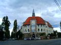
Roman Catholic Church Nagyboldogasszony (2007)

Central Reformed Church (2007)

Saint Joseph Church in Wekerletelep


_3.jpg)