
Martinsberg (Sibiu district)
|
Șomartin Martinsberg Mártonhegy |
|||||
|
|||||
| Basic data | |||||
|---|---|---|---|---|---|
| State : |
|
||||
| Historical region : | Transylvania | ||||
| Circle : | Sibiu | ||||
| Municipality : | Bruiu | ||||
| Coordinates : | 45 ° 51 ' N , 24 ° 40' E | ||||
| Time zone : | EET ( UTC +2) | ||||
| Height : | 451 m | ||||
| Residents : | 301 (2002) | ||||
| Postal code : | 557067 | ||||
| Telephone code : | (+40) 02 69 | ||||
| License plate : | SB | ||||
| Structure and administration | |||||
| Community type : | Village | ||||


Martinsberg ( Romanian Șomartin , Hungarian Mártonhegy ) is a village in Sibiu County in Romania . It is part of the Bruiu (Braller) municipality .
Geographical location

Șomartin is located in the Altland , east of the Harbachtal , in the south of the Transylvanian Basin in the historic Großschenker Stuhl . On the county road (drum județean) DJ 105A, the place is three kilometers southwest of the community center and about 30 kilometers from the small town of Agnita (Agnethlen) .
history
Șomartin was first mentioned in a document in 1337. The free Saxon community belonged to the Szentágota chair district in Greater Kokelburg County at the time of the Kingdom of Hungary and when the Făgăraş district (Județul Făgăraş) was abolished in 1950 , the village was assigned to the Bruiu community in today's Sibiu district.
According to Vasile Pârvan , Kurt Horedt and Paul Reinecke, archaeological finds in the area named Poro Luorcz by the locals were assigned to the Hallstatt period .
population
The population of Martinsberg developed as follows:
| census | Ethnic composition | ||||
|---|---|---|---|---|---|
| year | population | Romanians | Hungary | German | other |
| 1850 | 1,282 | 322 | 1 | 848 | 111 |
| 1920 | 1,190 | 446 | 10 | 734 | - |
| 1941 | 1,299 | 366 | 15th | 786 | 132 |
| 1977 | 722 | 256 | 11 | 408 | 47 |
| 1992 | 324 | 231 | - | 66 | 27 |
| 2002 | 302 | 264 | 2 | 14th | 21st |
Since 1850, Șomartin had its highest population in 1941. The highest number of Romanian Germans was registered in 1850, that of Romanians in 1920, of Roma (136) in 1930 and of Magyars in 1941.
Attractions
- The fortified church , built from a three-aisled basilica in the 13th century, was rebuilt in 1795 according to the Directory of Historical Monuments of the Ministry of Culture and National Heritage (Ministerul Culturii și Patrimoniului Național) and is a listed building. After the mass emigration of the Transylvanian Saxons to Germany, most of the art objects, pictures and statues were removed from the church and taken to a depot in Sibiu.
- The former German school and the event hall of the Protestant parish built at the beginning of the 20th century are left to decay.

Martinsberg fortified church with the hall

Interior of the orphaned Protestant church

Former German school
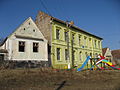
Former town hall, now a Romanian school

View from the church tower to the Romanian Orthodox Church


Web links
- Martinsberg at sevenbuerger.de
- Illustration by Daniel Meisner from 1626: Martinsberg. Asinus ad lyram ( digitized version )
Individual evidence
- ↑ Official German-language name according to Romanian government resolution 1415 of December 6, 2002 ( Official Journal ( Memento of September 5, 2018 in the Internet Archive ))
- ↑ Heinz Heltmann, Gustav Servatius (Ed.): Travel Guide Siebenbürgen . Kraft, Würzburg 1993, ISBN 3-8083-2019-2 .
- ↑ Institute Of Archeology - Şomartin , accessed on August 18, 2019 (Romanian).
- ↑ Censuses 1850–2002, last updated November 2, 2008 (PDF; 1 MB; Hungarian).
- ↑ List of historical monuments of the Romanian Ministry of Culture, updated 2015 (PDF; 12.7 MB; Romanian).