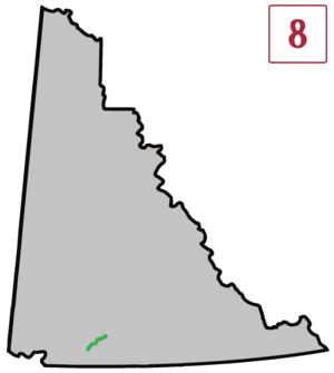
Tagish Road
| Highway 8 in Yukon, Canada | ||||||||||||||||||||||
| Tagish Road | ||||||||||||||||||||||

|
||||||||||||||||||||||
| map | ||||||||||||||||||||||
| Basic data | ||||||||||||||||||||||
| Operator: | Yukon Department of Highways and Public Works |
|||||||||||||||||||||
| Start of the street: |
Jake's Corner ( 60 ° 20 ′ N , 133 ° 59 ′ W ) |
|||||||||||||||||||||
| End of street: |
Carcross ( 60 ° 10 ′ N , 134 ° 42 ′ W ) |
|||||||||||||||||||||
| Overall length: | 53 km | |||||||||||||||||||||
|
Region : |
||||||||||||||||||||||
|
Course of the road
|
||||||||||||||||||||||
The Tagish Road (also known as Yukon Highway 8 ) is a 53 km long paved road in the Canadian Yukon Territory , which Jake's Corner on the Alaska Highway with Carcross on Klondike Highway connects.
About one mile from Jake's Corner is the end of Atlin Road . The small settlement of Tagish is about 12 miles from Jake's Corner.
Until the completion of the Alaska Highway in 1943 along Marsh Lake , Tagish Road was a section of the original Alaska Highway, and opened in the fall of 1942. For many years a long wooden bridge was the only way to cross the Tagish River . It has now been replaced by a more stable bridge, and the first 19 km of the road have also been straightened.
