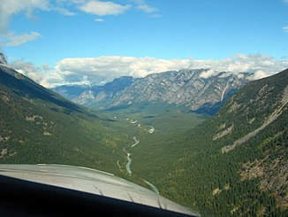
Talchako River
| Talchako River | ||
|
Looking north on the lower reaches of the Talchako River |
||
| Data | ||
| location | British Columbia (Canada) | |
| River system | Bella Coola River | |
| Drain over | Bella Coola River → Pacific Ocean | |
| origin |
Talchako Glacier in the Coast Mountains 52 ° 0 ′ 56 ″ N , 125 ° 54 ′ 22 ″ W |
|
| Source height | approx. 680 m | |
| Association with |
Atnarko River to Bella Coola River Coordinates: 52 ° 22 ′ 32 " N , 126 ° 5 ′ 22" W 52 ° 22 ′ 32 " N , 126 ° 5 ′ 22" W |
|
| Mouth height | approx. 140 m | |
| Height difference | approx. 540 m | |
| Bottom slope | approx. 12 ‰ | |
| length | 46 km | |
| Left tributaries | Jacobsen Creek, Ape Creek, Gyllenspetz Creek, Nordschow Creek | |
The Talchako River is the 46 km long left headwaters of the Bella Coola River in the Canadian province of British Columbia .
The Talchako River is fed by the Talchako Glacier . This is located in the Pacific Ranges , a part of the Coast Mountains . The Talchako River flows in a north-northwest direction through the mountains. It finally unites with the Atnarko River flowing in from the east to form the Bella Coola River. The course of the river runs along the western boundary of Tweedsmuir South Provincial Park .
Web links
- Talchako River . In: BC Geographical Names (English)
