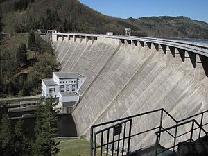
Vír I dam
| Vír I dam | |||||
|---|---|---|---|---|---|
| Dam wall | |||||
|
|||||
|
|
|||||
| Coordinates | 49 ° 33 '51 " N , 16 ° 18' 35" E | ||||
| Data on the structure | |||||
| Height of the barrier structure : | 71 m | ||||
| Height above valley floor: | 66.2 m | ||||
| Crown length: | 390 m | ||||
| Data on the reservoir | |||||
| Water surface | 223.5 ha | ||||
| Total storage space : | 56,193,000 m³ | ||||
| Reservoir | |||||
The Vír I dam (Czech: Vodní nádrž Vír I or also: Vírská přehrada ) is a drinking water dam in the Czech Republic . It is located six kilometers northeast of Bystřice nad Pernštejnem above the confluence of the Bystřice .
history
The first plans to build a dam emerged after the flood of March 15, 1940. The construction of the dam on the Svratka began in 1947. Until completion, the municipality of Chudobín and the villages of Hamry and Korouhvice were demolished and in 1958 flooded. The dam has been used to supply drinking water since the 1970s. The Vír I dam has a storage space of 56,193,000 m³ and an area of 223.5 hectares.
In 1992 the area around the dam was declared a first-rate water protection zone and the Vírovka and Ingstav holiday resorts by the lake had to be closed. Swimming and fishing is no longer allowed in the reservoir. Below is the Vír II dam .
Web links
- Vír I at pmo.cz


