
Tana (river)
| Tana | ||
 The Tana river system |
||
| Data | ||
| location |
|
|
| River system | Tana | |
| source | Mount Kenya massif | |
| muzzle | in Ungwana Bay in the Indian Ocean Coordinates: 2 ° 35 ′ 56 " S , 40 ° 20 ′ 19" E 2 ° 35 ′ 56 " S , 40 ° 20 ′ 19" E
|
|
| Catchment area | 126,026 km² | |
| Discharge at the Garissa gauge (1789300) A Eo : 42,220 km² Location: 250 km above the mouth |
NNQ (min. Month Ø) MNQ 1934–1975 MQ 1934–1975 Mq 1934–1975 MHQ 1934–1975 HHQ (max. Month Ø) |
13 m³ / s 68.6 m³ / s 155 m³ / s 3.7 l / (s km²) 365 m³ / s 1864 m³ / s |
| Reservoirs flowed through | Masinga , Kamburu , Guitaru , Kindaruma and Kiambere | |
| Medium-sized cities | Garissa | |
| Residents in the catchment area | 6,100,800 | |
| longest river in Kenya | ||
 Satellite image of the Tana Valley |
||
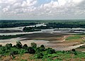
The Tana is Kenya's largest river. There are different information about its length between 700 and 1000 kilometers - a result of the fact that its beginning in the area of the Mount Kenya massif, which is covered by snow all year round, cannot be clearly determined.
geography
The Tana flows in the east of the Mount Kenya massif first to the north, then turns to the east and turns to the southeast, to finally reach the Indian Ocean in the Ungwana Bay after a long journey through dry bush and semi-desert area . The river has numerous rapids and waterfalls in the area of the Mount Kenya massif. In the further course it meanders more calmly through the landscape. However, in its lower part it can still be used in places for white water rafting.
On the banks of the river is also the eleven square kilometer Tana River Primate National Reserve, which is home to two species of monkey (the Tana colobus and the Tana mangabe ) as well as 262 bird and 57 mammal species. According to the World Bank, this project is suffering from the effects of river regulations. In addition, there are conflicts in this national park with the local population, who see themselves displaced.
The Tana is also bordered by the Kora National Park , where George Adamson (“Born Free”) lived until he was murdered in 1989 by Somali poachers.
Power plants and reservoirs
With seven dams and five hydropower plants , funded by the World Bank and national governments, humans have massively and financially intervened in the river's ecosystem. The river is vital to the power supply of the country, especially the capital Nairobi . Environmentalists complain about the displacement of the local population through the Kiambere Dam as well as the Buru irrigation project, which is considered to have failed and is now a drought landscape.
Looking downstream, the Tana is dammed by the following power plants:
| power plant | operator | Max. Power (MW) | Reservoir | Surface (km²) | Volume (km³) |
|---|---|---|---|---|---|
| Masinga | KenGen | 40 | Masinga | 120 | 1.56 |
| Kamburu | KenGen | 94.2 | Kamburu | 60 | 0.123 |
| Guitaru | KenGen | 225 | Guitaru | 0.016 | |
| Child aruma | KenGen | 72 | Child aruma | 2.4 | 0.016 |
| Kiambere | KenGen | 168 | Kiambere | 0.585 |
In the 1970s, feasibility studies for the expansion of hydropower on the Tana were carried out, which envisaged a cascade of 11 power plants. But so far only the above five have been implemented.
Hydrometry
The flow rate of the river was measured over 41 years (1934–75) in Garissa , a town about 250 kilometers upstream from the mouth. The mean annual flow rate observed in Garissa during this period was 155 m³ / s.

photos

The Tana 1998
The Tana 1998


Individual evidence
- ↑ http://www.nileiwrm.org/pdf/cases/Final Draft - Tana Water Basin, kenya.pdf (link not available)
- ↑ a b GRDC - The Tana in Garissa
- ↑ MASINGA POWER STATION. Kenya Electricity Generating Company , archived from the original on March 9, 2016 ; accessed on February 19, 2015 (English).