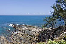
Tanjung Simpang Mengayau
Tanjung Simpang Mengayau or Tanjung Sampang Mangazou , also known as the Tip of Borneo , is a cape in the north of the Kudat district in the Malaysian state of Sabah . It is also the northernmost point of Borneo . Geographically, Tanjung Simpang Mengayau marks the point where the South China Sea meets the Sulu Sea .
The square is developed as a tourist attraction. In the middle of a park-like arrangement there is a square with the flag of Malaysia and a large bronze ball.
Origin of name
The original name Tanjung Sampang Mangazou comes from the language of the Rungus , an ethnic group often native to the Kudat district . The words Tanjung (peak), Sampang (union) and Mangazou (battle) indicate the location of a battle in which the ancestors of the Rungus defended their territory against a hostile invasion.
The Chinese people call the place Den Foh Liew ; in the Hakka language it means "lighthouse". This alludes to the lighthouse on the nearby island of Pulau Kalampunian , which can be clearly seen from here.
history
During his famous circumnavigation of the world, Ferdinand Magellan allegedly left his fleet at anchor here for 42 days to carry out repairs on the ships.
The Malaysian national flag (Jalur Gemilang) was first hoisted on the stormy afternoon of August 29, 2002 by the then Prime Minister of Sabah , Chong Kah Kiat . Previously, as part of the Malaysia Day celebrations, the flag was brought here by a troop of riders on a four-day ride from the Papar district, 274 kilometers away . This ride also entered the Malaysian Book of Records as the longest distance ride .
Bronze ball
The bronze ball was inaugurated on July 10, 2004 by Musa Aman , the Prime Minister of Sabah and bears the inscription on the flattened front:
|
The tip Of Borneo |
Web links
Individual evidence
- ↑ a b inscription on the back of the bronze ball; Translation from English. Explored on site on July 31, 2012
- ↑ inscription on the flagpole; Translation from English. Explored on site on July 31, 2012
Coordinates: 7 ° 2 ′ 14.1 ″ N , 116 ° 44 ′ 31.8 ″ E


