
Taouz
| Taouz الطاوس ⵟⴰⵡⵙ |
|||||
|---|---|---|---|---|---|
|
|||||
| Basic data | |||||
| State : |
|
||||
| Region : | Drâa-Tafilalet | ||||
| Province : | Errachidia | ||||
| Coordinates | 30 ° 54 ′ N , 4 ° 0 ′ W | ||||
| Residents : | 800 | ||||
| Height : | 675 m | ||||
 |
|||||


Taouz ( Arabic الطاوس, Central Atlas Tamazight ⵟⴰⵡⵙ ) is about 800 inhabitants Dattelpalmenoase and a rural municipality (commune rurale) with approximately 7,000 inhabitants in the province of Errachidia in the region Drâa Tafilalet in the southeast of Morocco . The area is disputed between Morocco and Algeria .
location
Taouz is located at the southern end of the RN13 on the east bank of the Oued Ziz, which is mostly dry in the south, a good 21 km (driving distance) south of the oasis settlement Merzouga near the not clearly defined border with neighboring Algeria at an altitude of about 675 m . The climate is desert-like; Rainfalls are extremely sparse (less than 80 mm / year).
Residents and economy
The population consists almost without exception of Berbers who, as extensive self-sufficiency, work hard to wrest what is necessary for their survival from the increasingly dry and barren oasis soils . In the vicinity of the place there are minerals sought after by collectors. Today Taouz acts as the central school location for the children of the surrounding villages.
history
In prehistoric times, hunters and gatherers roamed the region; they left numerous petroglyphs depicting wild animals. The later history of the place is closely connected with the once flourishing caravan trade in the Sahara - the numerous tumuli in the vicinity of the place , mostly made of bricks the size of bricks using the dry construction technique (see also Tazota ) , most likely served as burial sites for high-ranking personalities (tribal or caravan guide).
Attractions
Taouz itself offers the rather poor image of a desert town, even if in the last decades of the 20th and at the beginning of the 21st century some houses were built from hollow blocks and concrete. The old from rammed earth built houses of the village are almost all expire.
outside
- The stone tumuli at Jbel Kfiroun , about 2.5 km southwest of the village, are among the most remarkable examples of the Sahara cultures . Exactly from which time they come ( Neolithic , Ancient, Middle Ages or even early modern times) is completely unclear. They have a certain relationship with some similar buildings in northern Morocco (e.g. the tumulus of M'zora or the Bazina of El Gour ) but above all with other tombs in the Sahara (see web links).
- In a nearby valley further stone tumuli - albeit without a burial chamber - can be seen. Nearby there is a stone circle made up of vertically positioned slabs, the function of which is unclear.
- On a slab of rock in the immediate vicinity of the large tumulus there are several petroglyphs from a time when wild animals still lived in the region and were hunted by roaming groups of hunters and gatherers ; other petroglyphs show more abstract geometric ornaments.
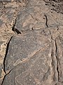
Taouz, rock carving

dito


- At Jbel Aoufilal, a little further away, there are rock drawings depicting four-wheeled chariots.
literature
- MC Gatto, DJ Mattingly et al. (Eds.): Burials, Migration and Identity in the Ancient Sahara and Beyond. Cambridge University Press, 2019, ISBN 978-1-108-47408-5 .
Web links
- Taouz, rock carvings and tumulus photos
- Archeology near Taouz - photos + information (French)
- Tumulus of Taouz - photo
- Tumulus tombs in the Sahara - photos + information (French)