Tapijulapa
| Tapijulapa | ||
|---|---|---|
|
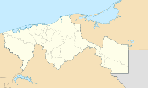
Coordinates: 17 ° 28 ′ N , 92 ° 47 ′ W Tapijulapa on the map of Tabasco
|
||
| Basic data | ||
| Country | Mexico | |
| State | Tabasco | |
| Municipio | Tacotalpa | |
| Residents | 2921 (2010) | |
| Detailed data | ||
| height | 60 m | |
| Post Code | 86870 | |
| Tapijulapa | ||
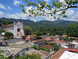
Tapijulapa is a place with about 3,500 inhabitants in the municipality ( municipio ) Tacotalpa in the south of the Mexican state Tabasco . The place has been recognized as Pueblo Mágico since 2010 because of its pretty townscape .
location
Tapijulapa is located at the confluence of the Oxolotán and Amatán rivers at an altitude of about 60 m above sea level. d. About 80 km (driving distance) south of Villahermosa , the capital of the state, near the border with the mountainous and wooded state of Chiapas .
Economy and Infrastructure
The inhabitants of earlier centuries were self-sufficient in farming, raising turkeys and hunting. Due to the location on two rivers that unite here to form the Río de la Sierra , a tributary of the Río Grijalva , the place was well developed for transport. Today one of the few road connections from Tabasco to Chiapas passes close to the town.
history
Tapijulapa is in the area of the Zoque - Maya . Small archaeological finds in the vicinity suggest that the place, which can be easily reached by boats, was already in the 5th / 6th centuries. Century AD was settled. In the years 1529 to 1531 Francisco de Montejo succeeded in suppressing Indian revolts in the region and opened up a safe route from the southern Gulf coast to Chiapas. The Franciscan order founded in 1533 in about 12 km southern city Oxolotán a mission station in 1572 by the Dominican order was taken and quickly grew in importance. A few years later, Diego de Landa , the Bishop of Yucatán , made an inspection tour of the region.
Attractions
- The townscape with its one or two-storey white-plastered houses, whose doors and windows are mostly reddish, is very uniform.
- The parish church ( Templo de Santiago Apóstol ) dates from the 17th century and is therefore one of the oldest churches in the region. It stands on a hill and can be reached via a 40-step staircase. The single nave interior has an open roof and two walled side altars ; it ends in a 5-step raised apse with a flat end.
Surroundings
- The Cueva de las sardinas ciegas , about 4 km to the south, is a nearby cave with a stream. On Palm Sunday, many Indians gather and hold traditional sacrificial rites that have a lot to do with candles and alcohol.
- There is a waterfall nearby ( Cascadas de Villa Luz ).
- The Grutas de Cuesta Chica , about 6 km to the south, were closed a few years ago because access for amateurs was too dangerous.
Web links
- Tapijulapa and surroundings - photos + information (Spanish)
- Tapijulapa and surroundings - photos + information (Spanish)
- Tapijulapa and surroundings - photos


