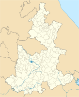
Tehuacan
| Tehuacan | ||
|---|---|---|
|
Coordinates: 18 ° 28 ′ N , 97 ° 23 ′ W Tehuacan on the map of Puebla
|
||
| Basic data | ||
| Country | Mexico | |
| State | Puebla | |
| Municipio | Tehuacan | |
| City foundation | 1660 | |
| Residents | 248,716 (2010) | |
| City insignia | ||
| Detailed data | ||
| height | 1896 m | |
| Website | ||
| Palacio Municipal of Tehuacan | ||
Tehuacán is a city in the Mexican state of Puebla with just under 250,000 inhabitants. Tehuacán is the seat of the Municipio Tehuacán and the Diocese of Tehuacán .
Tehuacán is located in a dry valley in which important information about the origin and development of agriculture in America has been obtained during extensive excavations. Here, for the first time, a continuous time sequence from the earliest settlement through plant domestication and ceramic production to the Spanish conquest in the 16th century could be provided.
The first traces of settlement by small wandering groups of hunters go back to around 9000 BC. BC back. In the El Riego phase (7000-5000 BC), the first domesticated plants ( garden pumpkin , avocado , amaranth , chilli and cotton ) were grown on a small scale by semi-nomadic groups . The first domesticated corn and beans appeared in the Coxcatlán phase (5000–3400 BC). In the Abejas phase, bowls and jugs were made from stone. The first permanent settlement for 3000 BC Chr. And the first ceramic is for the Purrón phase (2300–1500 BC).
sons and daughters of the town
- Joaquín Gutiérrez Heras (1927–2012), composer
- Francisco Uribe (born 1966), football player


