
Thanon Charoen Krung

The Thanon Charoen Krung ( Thai ถนน เจริญกรุง , English Charoen Krung Road , also New Road , German about "Road that the city grows / makes it richer") is a main traffic and business street in Bangkok , the capital of Thailand .
geography

The Thanon Charoen Krung is about eight kilometers long. It begins at the Grand Palace of Bangkok and runs almost parallel to the Mae Nam Chao Phraya (Chao Phraya River) on its eastern bank through the Bangkok districts of Phra Nakhon , Samphanthawong , Bang Rak , Sathon and Bang Kho Laem to a point that "Thanon Tok" ( ถนน ตก ), literally about: the road falls (into the river) is called.
history
Thanon Charoen Krung was built between 1861 and 1864 during the reign of King Ramas IV (Mongkuts) and was the first paved street in the metropolis. Previously, the city's traffic was mainly carried out on waterways, the khlongs , which is why Bangkok was also dubbed the “Venice of the East”. Your facility was one of the first steps in an extensive modernization and westernization of the capital founded in 1782. The construction of a paved road satisfied the needs of the western traders and diplomatic community in Bangkok for a safe and comfortable connection between the port area with the trade and consular missions in the south and the historical center of Bangkok around the Grand Palace . It was suggested by the American missionary Dan Beach Bradley , who lives in Siam , so that Bangkok could become one of the capitals of the "civilized world". Previously there was only an old elephant path on the route. In English usage it was given the simple name New Road . Modern commercial buildings were built along the new street that ran through the Chinese Quarter and the settlements of other foreigners and minorities.
The districts along Thanon Charoen Krung were the part of Bangkok that most resembled a European (or European colonized) city in the early 20th century. Businessmen and the first tourists found shops selling western goods and modern pharmacies here. One of the city's first tram lines ran on the street . However, this has since been discontinued.
Interesting places along the road
Northern part: from the palace to the city wall
- The Grand Palace and Wat Pho are both at the beginning of the street.
- The Sanam Saranrom - towards the end of the reign of King Mongkut (Rama IV.) He had the Saranrom Palace built east of the Grand Palace . After handing over the throne to his son Chulalongkorn, he retired to this palace. Today the former palace grounds are a public park.
- The Saphan Mon - the "Mon Bridge" over the Khlong Lod was originally built from teak during the reign of King Phra Nang Klao (Rama III) . It was replaced by a concrete bridge during the reign of King Vajiravudh (Rama VI) . The traders of the Mon ethnic group used to build their boat houses near this bridge.
- The Chalermkrung Royal Theater ( ศาลา เฉลิม กรุง ) - the oldest cinema in Bangkok and the first air-conditioned cinema in Thailand. King Prajadhipok (Rama VII) was enthusiastic about films that he had the cinema built from his own box. Prince Samaichalerm, who studied at the École des Beaux-Arts in Paris, designed the hexagonal building on Thanon Charoen Krung. The cinema was opened on July 2, 1933 by the king, who also chose the name. In 1992 the theater was completely renovated to bring it up to modern international standards. Films are rarely shown today, mainly for showing traditional Thai khon dramas.
- The Odeon Roundabout (Wong Wian Odeon) with the Chinese-style gate that marks the entrance to Bangkok's Chinatown.
- The Saphan Damrong Sathit ( สะพาน ดำรง สถิตย์ ) bridge over the Khlong Ong Ang ( คลอง โอ่ง อ่าง ). Since the reign of King Mongkut (Rama IV) there was a steel bridge with a wooden deck. Under King Chulalongkorn (Rama V) it was replaced by another steel bridge when both the Thanon Charoen Krung and the Damrong Sathit Bridge had to be widened. As a result of this expansion, a city gate called Sam Yot (Three Peaks), part of the city wall and even the gate to the palace of Prince Damrong Rajanubhab had to be demolished. Until today this bridge had to be widened twice in order to cope with the respective traffic.

Saranrome Park

Mon bridge

Chalermkrung Royal Theater

Chinese Gate on the Odeon Roundabout

Damrong Sathit Bridge


Southern part: from the city wall to Thanon Tok
- Saphan Phitaya Sathira - this bridge from 1895 over the Khlong Phadung Krung Kasem was initially a swing bridge with a steel frame. It was also called "Saphan Lek Lang" (Lower Steel Bridge) . In a report from 1887 the poor condition of this bridge was described, after which it was first repaired. After the chief engineer of the Ministry of Construction, Mr. Carlo Allegri, suggested measures to improve the flow of traffic on the Thanon Charoen Krung in 1895, the Saphan Lek Lang was replaced by a new, wider swing bridge. This new swing bridge remained in use until it was opened in the reign of King Rama VI. was replaced by today's concrete bridge.
- Bangkok Main Post Office - the building used to house the British Embassy.
- The Assumption Cathedral (Assumption Cathedral) - Catholic cathedral was built in 1822 by a Reverend Pascal, but in 1919 expanded. The Assumption School, run by Catholic lay brothers, is also located in its vicinity .
- The Hotel Oriental - the first hotel in European style, built in 1876 by two Danes, one of the most famous luxury hotels in Thailand.
- State Tower - one of the tallest skyscrapers in Bangkok
- Wat Yannawa - Royal Buddhist Temple ( Wat ) from the Ayutthaya period .
- Asiatique The Riverfront - former site of the Danish Østasiatiske Kompagni in Bangkok, now a leisure complex

Bridge over the Khlong Phadung Krung Kasem
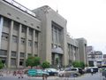
Bangkok's main post office

Assumption Cathedral
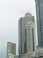
State Tower

Wat Yannawa

Asiatique leisure complex


.jpg)
literature
- Steve Van Beek: Bangkok then and now . AB Publications, Nonthaburi 2001, ISBN 974-87616-2-2 (English original edition from 1999: ISBN 974-87063-9-7 )
Individual evidence
- ↑ a b Maurizio Peleggi: Thailand. The Worldly Kingdom. Reaction Books, London 2007, p. 33.
- ↑ Maurizio Peleggi: Lords of Things. The Fashioning of the Siamese Monarchy's Modern Image. P. 79.
- ↑ Maryvelma O'Neil: Bangkok. A cultural history. Oxford University Press, Oxford / New York 2008, p. 18.
- ^ Marc Askew: Bangkok. Place, practice and representation. Routledge, London / New York 2002, p. 42.
- ↑ Page of the Ministry of Foreign Affairs on the history of the Saranrom Palace ( Memento of May 3, 2006 in the Internet Archive ) (in English)
- ↑ a b c Sirichai Narumit: Old Bridges Of Bangkok . The Siam Society, Bangkok 1977
Web links
Coordinates: 13 ° 44 ′ 49.7 " N , 100 ° 29 ′ 53.4" E