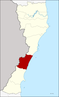
Amphoe Thap Sakae
|
Thap Sakae ทับสะแก |
|
|---|---|
| Province: | Prachuap Khiri Khan |
| Surface: | 538.0 km² |
| Residents: | 48,043 (2013) |
| Population density : | 88.3 U / km² |
| ZIP : | 77130 |
| Geocode : | 7703 |
| map | |

|
|
Amphoe Thap Sakae ( Thai : อำเภอ ทับสะแก ) is a district ( Amphoe - administrative district) in the southern part of Prachuap Khiri Khan Province . The province of Prachuap Khiri Khan is the southernmost province of the central region of Thailand .
geography
Neighboring Amphoe and Areas: Amphoe Mueang Prachuap Khiri Khan is to the north, Amphoe Bang Saphan is south of the district. To the west is the Tanintharyi Division of Myanmar and to the east is the Gulf of Thailand .
The Namtok Huai Yang National Park ( Huai Yang waterfall , อุทยานแห่งชาติ น้ำตก ห้วย ยาง ) is located here in Thap Sakae as well as in the Bang Saphan district. In the northeast is the Hat Wanakon Marine National Park, which includes a narrow coastal strip and the offshore islands.
history
The area of today's Thap Sakae district was separated from the Amphoe Mueang Prachuap Khiri Khan and Bang Saphan. Because the land was fertile and close to the sea, many people moved here and founded the three villages of Huai Yang, Ang Thong and Thap Sakae. As these villages got bigger, the government decided in 1938 to set up Thap Sakae as a "branch circle" ( King Amphoe ) . It was officially granted full amphoe status on July 23, 1958.
Attractions
- National Park Namtok Huai Yang ( Huai Yang Waterfall , อุทยานแห่งชาติ น้ำตก ห้วย ยาง ) - the 161 km² park was opened on December 8, 1991 as the 70th national park in Thailand .
- Marine National Park Hat Wanakon (อุทยานแห่งชาติหาด วน กร ) - The 18th Marine National Park was officially opened by royal decree on December 30, 1992. It is only 38 km² and is the smallest marine park in Thailand. 59.5% of the park is on the mainland, while the 40.5% water area includes the islands of Chan (Thai: เกาะ จาน ) and Thaisi (Thai: เกาะ ท้าย ท รี ย์ ), which are about 6 km off the coast.
administration
Provincial Administration
Thap Sakae County is divided into six tambon ("subdistricts" or "parishes"), which are further subdivided into 65 muban ("villages").
| No. | Surname | Thai | Muban | Pop. |
|---|---|---|---|---|
| 1. | Thap Sakae | ทับสะแก | 11 | 10,285 |
| 2. | Ang Thong | อ่างทอง | 11 | 8,636 |
| 3. | Well Hu Kwang | นา หูกวาง | 13 | 8,408 |
| 4th | Khao Lan | เขา ล้าน | 11 | 8,292 |
| 5. | Huai Yang | ห้วย ยาง | 13 | 8,526 |
| 6th | Saeng Arun | แสงอรุณ | 6th | 3,896 |
Local administration
There is one municipality with "small town" status ( Thesaban Tambon ) in the district:
- Thap Sakae (Thai: เทศบาล ตำบล ทับสะแก ) consisting of the parts of the tambon Thap Sakae, Khao Lan.
In addition, there are six " tambon administration organizations " ( องค์การ บริหาร ส่วน ตำบล - Tambon Administrative Organizations, TAO)
- Thap Sakae (Thai: องค์การ บริหาร ส่วน ตำบล ทับสะแก ) consisting of parts of the tambon Thap Sakae.
- Ang Thong (Thai: องค์การ บริหาร ส่วน ตำบล อ่างทอง ) consisting of the complete tambon Ang Thong.
- Na Hu Kwang (Thai: องค์การ บริหาร ส่วน ตำบล นา หูกวาง ) consisting of the complete tambon Na Hu Kwang.
- Khao Lan (Thai: องค์การ บริหาร ส่วน ตำบล เขา ล้าน ) consisting of parts of the Tambon Khao Lan.
- Huai Yang (Thai: องค์การ บริหาร ส่วน ตำบล ห้วย ยาง ) consisting of the complete tambon Huai Yang.
- Saeng Arun (Thai: องค์การ บริหาร ส่วน ตำบล แสงอรุณ ) consisting of the complete tambon Saeng Arun.
Individual evidence
- ↑ ประกาศ กระทรวง มหาดไทย เรื่อง ตั้ง กิ่ง อำเภอ ทับสะแก ขึ้น อำเภอ เมือง ประจวบคีรีขันธ์ จังหวัด ประจวบคีรีขันธ์ . In: Royal Gazette . 55, No. 0 ง , February 20, 1939, p. 3878.
- ↑ พระราชกฤษฎีกา จัดตั้ง อำเภอ กระสัง อำเภอ กระนวน อำเภอ บางกอกใหญ่ อำเภอ ขุน หาร อำเภอ พนา อำเภอ ปากช่อง อำเภอ วังเหนือ อำเภอ วัง ชิ้น อำเภอ แม่ทา อำเภอ หนอง หมู อำเภอ สระแก้ว สระแก้ว อำเภอ อมก๋อย อำเภอ บางซ้าย บางซ้าย อำเภอ ทับสะแก อำเภอ บุณฑริก อำเภอ ลานสะกา อำเภอ จอมบึง อำเภอ ท่ายาง อำเภอ สามเงา อำเภอ อำเภอ ชานุมาน บ้านเขว้า บ้านเขว้า บ้านเขว้า บ้านเขว้า บ้านเขว้า บ้านเขว้า อำเภอ แม่พริก อำเภอ ท่าสองยาง อำเภอ สะเมิง อำเภอ หนองแขม อำเภอ พระแสง พ.ศ. ๒๕๐๑ . In: Royal Gazette . 75, No. 55 ก , July 22, 1958, pp. 321-327.
- ↑ 2013 population statistics ( Thai ) Department of Provincial Administration. Retrieved September 11, 2014.
Web links
- More information about Amphoe Thap Sakae from amphoe.com (in Thai)
- Information about the Namtok Huai Yang National Park (in English)
- Information on Hat Wanakon National Park (in English)
Coordinates: 11 ° 30 ' N , 99 ° 37' E
