
Theodosius port

The Theodosius port ( Greek λιμήν Θεοδοσίου , Latin portus Theodosiacus ), also Eleutherios port ( Greek λιμήν Ἐλευθερίου ) was a port in the Byzantine Constantinople .
location
The port was on the south coast of Constantinople on the Marmara Sea in the south of today's Yenikapı district in the Istanbul district of Fatih . The city's other ports were Julian Port and the smaller port of Bukoleon Palace on the south and Neorion Port and Prosphorion Port on the north on the Golden Horn .
history

The port was first mentioned around 425 in the Notitia Urbis Constantinopolitanae and assigned to the 12th urban region ( regio duodecima ). However, the port was built earlier, possibly around 395 AD under Theodosius I , to relieve the existing moorings and to transport supplies for the city. In addition to everyday objects, grain from Egypt was landed, which was temporarily stored in grain stores.
The harbor was well protected. A sea wall protected the city and in 671/672 Emperor Constantine IV stationed several dromons equipped with fire- throwers in the port in response to the advance of the Arab fleet . In the late Palaeologi also were Molen towers built.
The area silted up in the following centuries due to the Lykos flowing into the port and this is said to have severely restricted traffic from the 12th century onwards.
The traveler and writer Pierre Gilles wrote in his book De topographia Constantinopoleos , published in 1561, of a largely buried harbor in which there were now extensive gardens. Several ponds provided for the irrigation of the plantations and are now considered the remains of the former harbor. A pier 12 feet wide and 600 paces long was still there. At that time, shipping was still possible at the still existing port mouth, which opened to the east. These remnants of the former port were filled in around 1759/1760 with earth that came from the construction site of the Laleli mosque . Sultan Mustafa III. created a new district here with the Yeni Mahalle. On a city view by the painter Konstantinos Kaldes from 1851, only a closed bank development can be seen in the area of Yenikapı.
Excavations 2005
In 2004, the Marmaray project was started, with which the expansion of the existing transport connections of the Istanbul subway system should be advanced. The plans envisaged a 76 km long railway line with 40 new stations along the Marmara coast. In addition, the European and Asian sides of the city were to be connected via a tunnel. In November 2005, workers discovered the remains of a port while building Yenikapı Station . Excavations confirmed that the site found was the old port from the 4th century. With an area of 58,000 square meters, the largest excavation site in Istanbul was created here.
In the upper layers, a good 3 meters below today's sea level, archaeologists from the Istanbul Archaeological Museum discovered the remains of the city wall , which had been built under Constantine the Great, and the structures of Ottoman workshops and craft workshops. The remains of 37 Byzantine ships from the 5th to 10th centuries were also found, including several Byzantine galleys that were first discovered here. They mainly contained lamps, kitchen utensils, amphorae with leftover food, weights, needles and game pieces, anchors, combs and turntables.
The excavations brought to light the oldest traces of the settlement of Constantinople. Neolithic objects of daily use were found at a depth of more than 6 meters , as well as bone fragments that date from around 6500 BC. The bone remains come from the Stone Age graves of a woman, a child and a man. Grave goods and grains of a domesticated type of grain were found. In addition, urns from the Neolithic were found for the first time at a Turkish site.
The number of animal skeletons found is unusual. More than 20,000 skeletons from 54 animal species have been excavated. The largest group of bone finds comes from horses, followed by cattle and sheep, but also pigs, dogs, donkeys and goats as well as chickens, geese and ducks. The large number of 240 camels and the relatively small number of cat skeletons are remarkable. Fish were also obviously traded, including tuna and dolphins. But there are also exotic animals: land and sea turtles, ostriches, elephants and bears, two primates and a gazelle.
Finds

Finds from Byzantine times
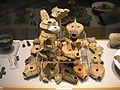
Oil lamps
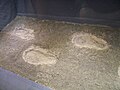
Footprints

Seeds
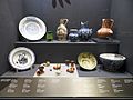
Plates and bowls

Bones of animals


literature
- Wolfgang Müller-Wiener : The ports of Byzantion, Konstantinupolis, Istanbul . Wasmuth, Tübingen 1994, ISBN 380301042X .
- Ufuk Kocabaş : Theodosius port and the shipwrecks of Yenikapi in Istanbul . In: Archeology in the Mediterranean. In search of lost shipwrecks and forgotten ports . Von Zabern, Darmstadt / Mainz 2013, pp. 82–89.
- Andreas Külzer : The Theodosios port in Yenikapı, İstanbul: a port area through the ages . In: Falko Daim (Ed.): Die Byzantinischen Häfen Konstantinopels (= Byzantium between Orient and Occident Volume 4, at the same time On the Ports from the Roman Empire to the Middle Ages in Europe Volume 3), Verlag des Römisch-Germanisches Zentralmuseums, Mainz 2016, ISBN 978-3-88467-275-4 , pp. 35-50 ( digitized version ).
Web links
- Alter Hafen opens a window into antiquity , Der Spiegel , July 24, 2006
Individual evidence
- ↑ a b c d e f g h i j Andreas Külzer: The Theodosios port in Yenikapı, İstanbul: a port area through the ages . In: Falko Daim (ed.): The Byzantine ports of Constantinople . Verlag des Römisch-Germanisches Zentralmuseums, Mainz 2016, ISBN 978-3-88467-275-4 , pp. 35–50.
- ↑ Mark Rose, Sengül Aydingün: Under Istanbul , Archaeological Institute of America, accessed on April 16 of 2019.
- ↑ The Treasure of the Turks under the U-Bahn , Die Welt , December 8, 2008
Coordinates: 41 ° 0 ′ 16.8 ″ N , 28 ° 57 ′ 8 ″ E