
Thurso (river)
| Thurso | ||
 |
||
| Data | ||
| location | Scotland | |
| River system | Thurso | |
| source |
Loch Rumsdale 58 ° 20 ′ 34 " N , 3 ° 49 ′ 24" W. |
|
| muzzle | At Thurso in the Pentland Firth coordinates: 58 ° 35 ′ 55 " N , 3 ° 30 ′ 43" W 58 ° 35 ′ 55 " N , 3 ° 30 ′ 43" W. |
|
| Mouth height |
0 m
|
|
| length | 43 km | |
| Flowing lakes | Hole More | |
The Thurso is a river in the Scottish Council Area Highland in the traditional Scottish county of Caithness . It rises in an unpopulated hilly region on the border with the county of Sutherland . From there it first flows in an easterly direction. After a few kilometers, the Glutt Water flows in from the south and the Thurso changes its direction of flow to the northeast. Then the Thurso flows through Loch More and its course bends a few kilometers afterwards to the north. The Thurso flows through the village of Halkirk and flows into the Pentland Firth at Thurso . The Thurso mostly flows through unforested, sparsely populated areas and is suitable for fishing.
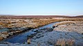
Glutt Water - a tributary of the Thurso

The Thurso at Halkirk

Estuary at Thurso


Individual evidence
- ↑ OSM card
- ↑ a b Thurso. In: Francis H. Groome: Ordnance Gazetteer of Scotland: A Survey of Scottish Topography, Statistical, Biographical and Historical. Volume 6: (Pet - Zet). Thomas C. Jack, Grange Publishing Works, Edinburgh et al. 1885, pp. 437-439.
- ^ Thurso, River. In: David Munro, Bruce Gittings: Scotland. An Encyclopedia of Places & Landscapes. Collins et al., Glasgow 2006, ISBN 0-00-472466-6 .