
Thurso
|
Thurso Scottish Gaelic Inbhir Theòrsa |
|||
|---|---|---|---|
 |
|||
| Coordinates | 58 ° 36 ′ N , 3 ° 32 ′ W | ||
|
|||
| Residents | 7933 2011 census | ||
| administration | |||
| Post town | THURSO | ||
| ZIP code section | Week 14 | ||
| prefix | 01847 | ||
| Part of the country | Scotland | ||
| Council area | Highland | ||
| British Parliament | Caithness, Sutherland and Easter Ross | ||
| Scottish Parliament | Caithness, Sutherland and Ross | ||

Thurso ( Scottish Gaelic Inbhir Theòrsa ) is a port city with 7933 inhabitants in the far north of Scotland .
location
The city is located in the former county of Caithness and the Council Area Highland , about 300 kilometers as the crow flies from Glasgow and Edinburgh and 800 km from London . Thurso is the northernmost city on the main British island. The Thurso River flows through the town and flows into the Pentland Firth in Thurso Bay .
history
The name of the city is derived from old Norwegian . There are two interpretations: water of the bull or river of Thor ( Thorsaa )


In the area of the city there are traces of prehistoric settlement like the Cairns of Tulloch of Assery . This settlement, from which Thurso developed, was founded by Vikings around 1000 AD due to its convenient location as the northernmost Scottish port on the British main island across from Norway , the Orkney and Shetland Islands . Their first castle was in the area of today's Thurso train station; it was inhabited until the 18th century. There is nothing to be seen there today. The Viking rule ended in 1266, the center of which was on the Orkney Islands. Thurso was an important port for traffic in the North Sea until the 18th century . It now belonged to the sphere of influence of the Counts of Caithness, who built a new castle on the coast, east of the village. It has been preserved as a ruin.

A first, planned city expansion with a "grid plan" was laid out in the first half of the 19th century by the local landowner and politician John Sinclair . However, it was a bit large for the needs of the time and was only partially built on with residential houses, initially from the Regency and later from the Victorian era .

Since the 19th century, a layer of stone found in the area has been quarried on a large scale, which was ideal for paving slabs. These plates were exported all over the world. They can be found on the streets of Sydney or Montevideo . This export boom also benefited the port of Thurso. In the heyday of this industry it had up to 500 employees. From the 1920s, however, concrete slabs were increasingly used, so that this branch of business fell sharply. A permanent population decline set in, which could only be reversed from 1955 with the construction of the nuclear reactor , a fast breeder in Dounreay , 14 km west of Thurso. A second planned city expansion followed. Within a period of just under ten years, Thurso's population grew from around 3,000 to around 9,000. The reactor was shut down in 1977 , but the aftercare work still keeps a lot of people busy.
Residents
With 7,933 inhabitants in 2011 Thurso is the largest town in County Caithness.
economy
Originally, fishing was the main livelihood. Even if it is no longer as important as it was 50 years ago, it is still an important economic factor in the structurally weak region.
The nuclear reactor in Dounreay has been dismantled since 1977. The United Kingdom Atomic Energy Authority (UKAEA) together with the Ministry of Defense is still the main employer (Dounreay Nuclear Power Development Establishment). Nuclear fuel rods are also processed there.
Another line of business is tourism, particularly in connection with the ferry to the Orkney Islands.
Town twinning
Since 1980 there has been a twinning with the German city of Brilon .
Infrastructure
rail

The city is the northern terminus of the Far North Line coming from Inverness and thus has the northernmost train station in Great Britain. The railroad reached Thurso in 1874. Today four pairs of trains run on weekdays and two pairs of trains on Sundays.
Street
Thurso is on the A9 , which connects it to Inverness, and the A836 , which runs along the north coast of Scotland.
air traffic
A good twelve kilometers west of the city is an airfield of more regional importance. The city of Wick, 35 kilometers south-east, has a larger airport with regular scheduled flights.
port

The port of Scrabster , about two kilometers west of Thurso Bay, is now also the fishing port of Thurso. It is a deep water port. Car ferries run regularly from there to the Orkney Islands, almost without exception to the small port town of Stromness on the island of Mainland . In June 2007 a weekly ferry service from Scrabster with the Faroe Islands , Shetland Islands , Iceland , Denmark and Norway was started in the summer, but has since been discontinued.
Tourism and sightseeing
Tourism is now an important line of business in Thurso, but mainly related to ferry traffic to the Orkney Islands. There are hotel beds, bed and breakfast accommodation, two hostels and a campsite.
With Wolfburn, Thurso is the northernmost whiskey distillery on the Scottish mainland.
Cultural institutions
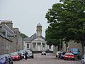
The local history museum was reopened in 2008 under the name Caithness Horizons in the former town hall and the attached library . It provides information about the history of the city, from prehistory to the fast breeder in Dounreay and the natural history of the area.
There is a public library.
Historic Buildings

- Ruin of Thurso Castle
- Ruin of the Old St Peter's Church. It dates from at least the 12th century, the oldest surviving parts were built around 1220; most of what is still standing is from the 15th and 16th centuries. It was the main medieval church in town and was abandoned in 1833.
- The neo-Gothic St. Peter's and St. Andrew's Church replaced the medieval St Peter's Church in 1833. It stands in the line of sight of the River Thurso Road Bridge .
- The River Thurso Road Bridge (there are also two pedestrian bridges that cross the river) dates from 1877. It replaced an older bridge from 1800. Before, the river could only be crossed by ferry. Bridge tolls were levied until 1878 . The customs house at the east end of the bridge has been preserved and now houses a gallery.
- Planned city expansion with a "grid floor plan" from the first half of the 19th century with numerous, often exemplary, well-kept historic houses from the Regency and the Victorian era .
Surroundings

A few kilometers to the northeast is Dunnet Head , a cape rising 114 meters from the sea with a lighthouse and a bird sanctuary, which is also the northernmost land point on the British main island.
The Castle of Mey on the way between Thurso and Dunnet Head has become a special attraction . Elisabeth, Queen Mother, resided here from 1955 until her death in 2002 . Today the palace and park are open to visitors in the summer when it is not in use by a member of the royal family.
Educational institutions
- various elementary schools
- Thurso High School
- North Highland College is part of the University of the Highlands and Islands
Personalities
Sons of Thurso
- Arthur St. Clair (1736-1818), American general and politician
- John Sinclair (1754–1835), statistician and economist
- Andrew Geddes Bain (1797–1864), geologist and paleontologist , made important fossil finds and created the first geological map of South Africa
- William David Ross (1877–1971), philosopher
- Bryan Gunn (* 1963), soccer player and coach
- Gary Mackay-Steven (* 1990), soccer player
Citizen of Thurso
- Robert Dick (1811–1866), worked as a baker in Thurso from 1830 and researched the botany of the Scottish Highlands from here , as well as sea shells and fossils
literature
- New Century Publishing Group: Caithness Explorer 2009 .
- David McConell: Rails to Wick & Thurso . n.d. [before 1990]. Dornoch, Dornoch Press. ISBN 0951335871 .
- Eann Sinclair: Three Walks in Thurso . Caithness Tourist Board 1993.
Web links
Individual evidence
photos

Thurso with Scottish coat of arms flag

Historic town hall, now a museum
library

railway station

St. Peter and St. Andrew Church
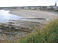
Beach


