
Tiedexer Strasse
| Tiedexer Strasse | |
|---|---|
|
|
|
 |
|
| View from Tiedexer Tor to the northern row of houses | |
| Basic data | |
| place | Einbeck |
| District | Old town |
| Created | 12th Century |
| Newly designed | 16th Century |
| Connecting roads | Tiedexer Tor , Steinweg, Market Square , Hullers Wall |
| Cross streets | Götgengasse |
| Technical specifications | |
| Street length | 200 m |
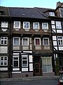
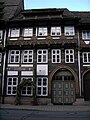
The Tiedexer Straße is a street in the old town of Einbeck in Lower Saxony . Due to its well-preserved closed row of half-timbered houses from the mid-16th century, it is a complex of special cultural and historical value and one of the streets in the historic old town most frequently photographed by tourists. 15 of the 16 houses on the north side of the street are listed buildings .
middle Ages
The almost 200 m long Tiedexer Straße connects the market church on the western side of the market square with the former Tiedexer Tor in the west of the old town. In its continuation in front of the gate was the Marienstift and the eponymous place Tiedexen , which was abandoned in the 14th century. The Tiedexer road was part of an old remote trade route from west to east through the resulting in the 12th century market town south of Bachaue the crooked water , making it one of the oldest streets in the city. In front of the gate, the road along the floodplain was paved with up to 2 m long trunks that were dendrochronologically dated to the early 13th century. The fortification of the Tiedexer Straße within the city is not known, however, in other parts of the old town, a simple gravel of streets in the Middle Ages has been proven archaeologically. The originally about 20 m wide, loosely built parcels along the street, each with a half-timbered house, were about 70-75 m long on the southern side of the street and only 30-35 m on the northern side due to the nearby brook floodplain.
The chronicler Harland reports that the old town was flooded by the Krumme Wasser from Tiedexer Tor in August 1486 and that the Tiedexer Straße with the market was particularly affected.
Modern times

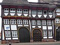
The houses on the street last burned down in 1540 - like the entire city . A few years later they were rebuilt in a late Gothic half-timbered construction in a closed row, as can be seen from the carved dates (1541 to 1550) above the arches. The three-storey half-timbered houses were erected in post-and-beam construction , the compartments plastered with wickerwork and clay. The second floor protrudes. The sill beams and lugs on the upper floor are decorated with ornamental carvings such as a bow frieze or braided band and fan rosettes . The high arches of different widths, also with ornamental carvings as well as inscriptions, house brands and guild signs, indicate citizens who are entitled to brew beer. Through the gates which was Braupfanne brought into the hall for regular contemporary home brewing. The narrow dormers in the steep roofs served as ventilation slots for drying raw materials for brewing beer. The roofs of different heights are all aligned with the eaves facing the street. After a council decision of 1553 on fire protection, the houses in the city could only be covered with the heavy Solling sandstone slabs.
Over the past centuries, renovations have been carried out repeatedly. Formerly often existing bay window upstairs were (probably in the 18th century) dismantled. The large gates were locked and instead smaller doors were installed, and windows were enlarged, especially on the ground floor. In the 19th century, the facades of the half-timbered houses were completely plastered as structural fire protection and the roofs were often covered with modern tiles. The plaster was not removed from some of the houses on Tiedexer Strasse until the second half of the 20th century. The re-exposed carvings were painted in polychrome. Today almost all listed houses on the north side of the street have been modernized and restored in accordance with the listed buildings.
No. 26 from 1541 with a modern roof, door and window
No. 20a from 1542 with ornamental beams from the former bay window from 1556

Tiedex gatehouse with passage from 1964
crooked house, Tiedexer Straße No. 30/32


swell
- Peter Sobeck: 1974 to 2007. 33 years of urban redevelopment in Einbeck . Ed .: City of Einbeck. 2007, p. 52-65 .
- Andreas Heege: Einbeck in the Middle Ages . Isensee, Oldenburg 2002, ISBN 3-89598-836-7 .
Individual evidence
- ↑ HL Harland: History of the city of Einbeck: along with historical news about the city and the former county of Dassel, the villages, churches, chapels, monasteries, castles and noble seats around Einbeck . 1st volume. H. Ehlers, Einbeck 1854, p. 261 . ( online )
Web links
- private, extensive photo gallery of Tiedexer Str.
- Historic half-timbered row of Tiedexer Strasse in Einbeck through the ages in the Einbecker Morgenpost from 6 September 2011
Coordinates: 51 ° 49 ′ 8 ″ N , 9 ° 51 ′ 56 ″ E