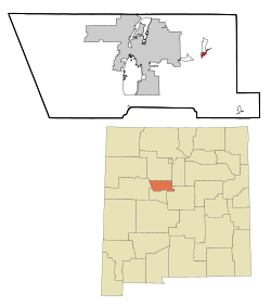
Tijeras
| Tijeras | |
|---|---|
|
Location in New Mexico
|
|
| Basic data | |
| State : | United States |
| State : | New Mexico |
| County : | Bernalillo County |
| Coordinates : | 35 ° 5 ' N , 106 ° 23' W |
| Time zone : | Mountain ( UTC − 7 / −6 ) |
| Residents : | 474 (as of: 2000) |
| Population density : | 215.5 inhabitants per km 2 |
| Area : | 2.2 km 2 (approx. 1 mi 2 ) of which 2.2 km 2 (approx. 1 mi 2 ) are land |
| Height : | 1927 m |
| Postal code : | 87059 |
| Area code : | +1 505 |
| FIPS : | 35-77880 |
| GNIS ID : | 0911709 |
Tijeras is a village in Bernalillo County , New Mexico , USA . The community had 474 inhabitants in 2000 and is located in the Tijeras Canyon, which separates the Sandia Mountains in the north from the Manzano Mountains in the south. Tijeras is on an important crossroads that leads north to Cedar Crest , Sandia Park , Madrid and Santa Fe . To the west to Albuquerque , to the south to the Manzano Mountains and to the east to Edgewood .
