TIROS
In the TIROS program, the first generation of which ran between 1960 and 1966, there were ten satellites. This program was started by the USA . Tiros 1 was the first satellite to determine and forecast the general weather situation and to transmit images of the cloud fields to the earth stations. Were used vidicon TV's cameras to observe the schematic of the cloud cover.
TIROS stands for T elevision and I nfra R ed O bservation S atellite (German: TV camera and infrared observation satellite ).
The second-generation US weather satellite research program was called the Nimbus Program (started 1968–1978). The satellites - seven of them - were in sun-synchronous polar orbits .
Satellite list
First generation
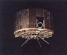
The satellites were shaped like a low cylinder with a diameter of 1.07 m and a height of about 0.5 m. They were equipped with two camera systems (Vidicon wide-angle cameras with a resolution of around 3 km and a swath width of up to 1200 km) and radiation measuring devices ( bolometers with a resolution of 50 km). They provided evidence that satellites can be used for daily weather monitoring.
The satellites were operated by the Environmental Science Services Administration (ESSA), development was carried out by the Goddard Space Flight Center (GSFC) and produced by the Radio Corporation of America (RCA). Other project participants were the National Aeronautics and Space Administration (NASA) and the National Oceanic and Atmospheric Administration (NOAA). The first two satellites, named after the operator authority ESSA , still corresponded to the development status of the first generation.
- TIROS 1 - launched: April 1, 1960, suffered an electrical system failure on June 15, 1960, but delivered well over 15,000 images by then
- TIROS 2 - launched November 23, 1960, failed January 22, 1961
- TIROS 3 - launched July 12, 1961, deactivated February 28, 1962
- TIROS 4 - launched: February 8, 1962, failure on June 30, 1962 (both cameras failed earlier)
- TIROS 5 - launched: June 19, 1962, failure on May 13, 1963
- TIROS 6 - launched: September 18, 1962, failure on October 21, 1963
- TIROS 7 - launched June 19, 1963, deactivated June 3, 1968
- TIROS 8 - launched: December 21, 1963, deactivated on July 1, 1967, first satellite to use the APT method
- TIROS 9 - launched: January 1, 1965, failure on February 15, 1967, first Tiros satellite near the polar orbit
- TIROS 10 - launched July 2, 1965, deactivated July 31, 1966
- ESSA-1 (OT-3), February 3, 1966
- ESSA-2 (OT-2), February 28, 1966
TIROS Operational System
In contrast to the TIROS satellites, the satellites of the TIROS Operational System (TOS) were no longer purely research projects, but were used operationally for climate research , earth observation and weather forecasting . As with TIROS, the operator was ESSA, the satellite design was carried out by GSCF and RCA was commissioned with production.
- ESSA-3 (TOS-A), October 2, 1966
- ESSA-4 (TOS-B), January 26, 1967
- ESSA-5 (TOS-C), April 20, 1967
- ESSA-6 (TOS-D), November 10, 1967
- ESSA-7 (TOS-E), August 16, 1968
- ESSA-8 (TOS-F), December 15, 1968
- ESSA-9 (TOS-G), February 26, 1969
ITOS and TIROS-M
The first NOAA satellites also come from this third generation , satellites in cubic form (1.02 * 1.02 * 1.24 m³) with solar cell booms (91.5 * 165 cm² with a total of 3420 solar cells). The first satellites in the series (mass: 306 kg) were equipped with two APT cameras (Automatic Picture Transmission) and two video cameras (AVCS - Advanced Vidicon Camera System) and with a double scanning line perpendicular to the flight path in the range 0.52 to 0 .73 µm (on the day side of the earth) and 10.5 to 12.5 µm (on the night side). The resolution was 3 to 6 km. In addition, the satellites carried a radiometer for determining the heat balance of the earth and a proton flow meter as a secondary payload . One of the four antennas was used to receive commands from the earth and to transmit a bearing signal, two for continuous data transmission to earth and one for the transmission of stored data in the S-band . From NOAA-2 (mass: 409 kg) the cameras were omitted in favor of the line scanner with a resolution of ~ 8 km. As of NOAA-3, an improved line scanner (resolution 0.9 km) and an additional measuring device for obtaining vertical temperature profiles in the frequency range of 15 µm were used.
- TIROS-M (ITOS-1), January 23, 1970
- NOAA-1 (ITOS-A), December 11, 1970
- ITOS-B , October 21, 1971
- ITOS-C , not started
- NOAA-2 (ITOS-D), October 15, 1972
- ITOS-E , July 16, 1973
- NOAA-3 (ITOS-F) November 6, 1973
- NOAA-4 (ITOS-G) November 15, 1974
- NOAA-5 (ITOS-H) July 29, 1976
TIROS-N
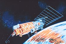
TIROS-N is a technically improved version of the Tiros satellites with a mass of around 1400 kg and a length of 3.66 m. They circled the earth on a sun-synchronous orbit with an orbit inclination of 97 ° at an altitude of 833 to 870 km and were used in pairs (offset by 90 ° to each other on the orbit). The satellites had three-axis stabilization and, among other things, a high-resolution radiometer (VVHRR) for mapping the water surface temperature and for day / night overview images, a device (HIRS) for determining temperature and humidity profiles in the troposphere , a device (SUU) and a four-channel spectrometer (MSU) in the 60 GHz range for determining temperature profiles of the stratosphere and a radiation measuring device for local electrons and protons .
Advanced TIROS-N
The satellites of this generation were also equipped with devices for the COSPAS-SARSAT search and rescue system.
- NOAA-8 (E) March 28, 1983
- NOAA-9 (F) December 12, 1984
- NOAA-10 (G) September 17, 1986
- NOAA-11 (H) September 22, 1988
- NOAA-12 (D) May 14, 1991
- NOAA-13 (I) August 9, 1993
- NOAA-14 (J) December 30, 1994
- NOAA-15 (K) May 15, 1998
- NOAA-16 (L) September 21, 2000
- NOAA-17 (M) June 24, 2002
- NOAA-18 (N) May 20, 2005
- NOAA-19 (N ') February 6, 2009
Web links
- NOAA: April 1, 1960 - TIROS I is Launched (English)
- Gunter's Space Page: Tiros 1, 2, 3, 4, 5, 6, 7, 8, 10 (English)
- NASA: TIROS (English)
Individual evidence
- ^ TIROS in the Encyclopedia Astronautica , accessed on October 18, 2010 (English).
- ^ TOS in the Encyclopedia Astronautica , accessed on October 18, 2010 (English).
- ↑ ITOS 1 in the NSSDCA Master Catalog , accessed on October 18, 2010 (English).


