Tokachi-dake
| Tokachi-dake | ||
|---|---|---|
|
Tokachi-dake in May 2006 |
||
| height | 2077 m TP | |
| location | Central Hokkaidō , Japan | |
| Coordinates | 43 ° 25 '1 " N , 142 ° 41' 11" E | |
|
|
||
| Type | active stratovolcano | |
| Last eruption | 2004 | |
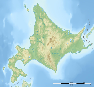
The Mount Tokachi ( Jap. 十勝岳 , 2077 m TP ) is an active layer of volcanic on the Japanese island of Hokkaido . It is located in the Daisetsuzan National Park in the center of the island and is 25 kilometers northeast of Furano . About two kilometers northeast of the Tokachi-dake there is another active volcano, the Biei-dake . For the past 10,000 years, the Tokachi-dake eruptions have been accompanied by pyroclastic ejection and lava flows and are classified as Strombolian and mild to moderate Plinian eruptions . Since the winter season in the Tokachi-dake area is long, the risk of pyroclastic mud currents, so-called lahars , is quite high. There were two major eruptions in the 20th century, in 1926 and 1962.
Formations of the volcano
The Tokachi-dake includes several predominantly andesitic stratovolcano cones and lava domes , which are arranged along a line running from northeast to southwest. The volcano rises above a plain made up of Pleistocene tuff . Some explosion craters and cinder cones are found on the upper flanks of the volcano, with the most recent formations formed during the Holocene being found on the northwestern part of the mountain.
Eruptions
Numerous eruptions are known in historical times, most of which were accompanied by light to moderate phreatic explosions . The last two major eruptions occurred in 1926 and 1962. During the eruption of 1926, part of the central cone collapsed and an avalanche of rubble and mud wreaked havoc on the northwest flank. A new volcanic crater with a diameter between 130 and 300 meters was created. Some minor eruptions occurred from December 1988 to April 1989, and a very minor eruption was recorded in April 2004.
In December 2014, the Japan Meteorological Agency raised the warning level for the Tokachi-dake to 2 due to increased seismic activity in the area, as a smaller eruption is believed to be possible. This warning level is linked to the recommendation not to get closer than one kilometer to the most important crater formed in the 1962 eruption.
Individual evidence
- ↑ a b M. Murakami, M. Nakagawa: Tokachidake. In: Japan Meteorological Agency: National catalog of the active volcanoes in Japan. 4th edition, English version, July 2013 ( online )
- ↑ a b c Tokachidake in the Global Volcanism Program of the Smithsonian Institution (English)
- ↑ Martin Schwind : The Japanese island kingdom: The natural landscape. , de Gruyter, Berlin 1967, ISBN 3 11 000721 5 , p. 131 ( Google books )
- ↑ earth-of-fire.com: The Tokachidake on alert level 2 in Hokkaido. Retrieved January 8, 2015
- ↑ Japan Meteorological Agency: Volcanic Warnings (Hokkaido). Retrieved January 8, 2015

