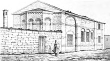
Toklu Dede Mosque
The Toklu Dede Mosque ( Turkish Toklu Dede Mescidi ) was a Byzantine church that was converted into a mosque during the Ottoman Empire . In 1929 the structure was largely destroyed. Only the south wall was preserved with a few frescoes.
location
The mosque is located in the Ayvansaray district in the Fatih district of Istanbul . The only remaining remnant of the building, the southern wall, is now part of a modern house on Toklu İbrahim Dede Sokak . The building was located within the Theodosian Wall on the Golden Horn, only a few meters away from the former sea and Blachernae wall. It was built at the foot of the northern slope of the sixth hill of Constantinople in the district of ta Karianou , which was part of the Blachernae district.
history
Byzantine period
The origins of the church are in the dark. The narrow structure was located within the Heraclius Wall less than 100 meters west of the now destroyed Küçük Ayvansaray Gate (Koiliomene Gate) and east of the Blachernae Gate. The church was equated with the nearby Atik Mustafa Pascha mosque of the Church of St. Thekla of the Blachernae Palace ( Greek Άγία Θέκλα τοῦ Παλατίου τῶν Βλαχερνών , Hagia Thekla tou Palatiou tōn Vlakhernōn ). Since the building is too far away from the palace for that, this attribution, which was made solely because of the similarity of names, has now been rejected. According to the art historian Semavi Eyice , the building could also be the Church of St. Priskos and ASt. Nikolaos have been, which was founded in the 6th century.
At the beginning of the 14th century, the building was in the time of Palaiologoi architecturally changed slightly dynasty and renews the frescoes inside.
Ottoman time
After the conquest of Constantinople by the Ottomans , the church was converted into a mosque at the end of the 15th or beginning of the 16th century by Toklu İbrahim Dede, a former officer of Mehmed II and overseer at the tomb of Muhammad's companion Ebû Șeybet ül Hudrî.
Current
In 1929 the owner at the time almost completely destroyed the building. Only the south wall and the apse remained. The first archaeological work took place in 1954. The frescos obtained were preserved. Today only the south wall is preserved, but it is part of a modern building.
description
Stylistically, the building can be assigned to the Komnenen era (middle or second half of the 11th century). The structure had a rectangular floor plan with a length of 14.2 meters and a width of 6.7 meters. The nave was spanned by a barrel vault and crowned by a dome with a diameter of four meters. The dome was supported by arches on angular pillars. In front of the nave was an esonarthex . To the east, the nave was adjoined by a bema with a polygonal apse, which was decorated with niches outside and inside. The floor plan of the building is based on that of the Chora Church on a smaller scale. The masonry of the church consisted of rows of white ashlar and red bricks, creating a band. The outer wall was structured by semicircular columns and pilaster strips with arches. The church was painted with frescoes from the 14th century. Portraits of Saints Eleutherius , Abercius , Polycarp of Smyrna , Spyridon , Procopius and Nicetas of Remesiana have survived . Some of the pictures were framed by medallions . The barrel vault above the altar showed a fresco with the Christmas story .
Web links
Individual evidence
- ↑ a b c d e f g h i Wolfgang Müller-Wiener : Pictorial dictionary on the topography of Istanbul: Byzantion, Konstantinupolis, Istanbul up to the beginning of the 17th century . Wasmuth, Tübingen 1977, ISBN 978-3803010223 , p. 206.
- ^ Archaeological Destruction in Turkey, preliminary report. Marmara Region - Byzantine , TAY Project, p. 29 (PDF)
- ^ Raymond Janin : Les Églises et les Monastères . (= La Géographie Ecclésiastique de l'Empire Byzantine . 1st part: Le Siège de Constantinople et le Patriarcat Oecuménique , 3rd volume), Institut Français d'Etudes Byzantines, Paris 1953
- ↑ Wolfgang Müller-Wiener : Picture dictionary on the topography of Istanbul: Byzantion, Konstantinupolis, Istanbul up to the beginning of the 17th century . Wasmuth, Tübingen 1977, ISBN 978-3803010223 , p. 302
- ^ Raymond Janin: Les Églises et les Monastères . (= La Géographie Ecclésiastique de l'Empire Byzantine . 1st part: Le Siège de Constantinople et le Patriarcat Oecuménique , 3rd volume), Institut Français d'Etudes Byzantines, Paris 1953, p. 148.
- ^ Semavi Eyice : Istanbul. Petite Guide a travers les Monuments Byzantins et Turcs . Istanbul Matbaası, Istanbul 1955, p. 66
- ↑ Çelik Gülersoy : A Guide to Istanbul . Istanbul Kitaplığı, Istanbul 1976, p. 248
- ↑ a b c d Richard Krautheimer : Architettura paleocristiana e bizantina . Einaudi, Turin 1986, ISBN 88-06-59261-0 , p. 409
- ^ A b c Robert G. Ousterhout: The Architecture of the Kariye Camii in Istanbul . Dumbarton Oaks, Washington DC 1987, ISBN 0-88402-165-3 , p. 23
- ↑ Wolfgang Müller-Wiener : Picture dictionary on the topography of Istanbul: Byzantion, Konstantinupolis, Istanbul up to the beginning of the 17th century . Wasmuth, Tübingen 1977, ISBN 978-3803010223 , p. 207
Coordinates: 41 ° 2 ′ 22.2 " N , 28 ° 56 ′ 33" E

