Tomales Bay
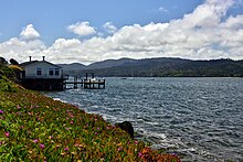
Tomales Bay is a long, narrow bay on the Pacific Ocean in Marin County in Northern California in the United States . It is located approximately 50 km northwest of San Francisco .
geography
The bay is approximately 25 km long and an average of 1.6 km wide, separating the Point Reyes Peninsula from the mainland of Marin County . At its northern end it opens to Bodega Bay , which protects it from the currents of the Pacific Ocean .
Towns adjacent to Tomales Bay include Inverness, Inverness Park, Point Reyes Station, and Marshall. Other hamlets include Nick's Cove, Spengers, Duck Cove, Shallow Beach and Vilicichs. Dillon Beach is north of the mouth of the bay and Tomales to the east.
The bay forms the eastern boundary of the Point Reyes National Seashore . Tomales Bay is recognized by the California Bays and Estuaries Policy for Conservation. Of particular interest is bioluminescence , which can be observed from June to November.
The bay was formed along a submerged part of the San Andreas Fault . A small educational trail about the effects of the earthquakes on the region and in particular the great 1906 earthquake in San Francisco is at the visitor center of the Point Reyes National Seashore on the peninsula.
Economic use
Oyster farming is an important industry in the bay. The two largest producers are Tomales Bay Oyster Company and Hog Island Oyster Company, both of which sell oysters to the public and offer picnic spots on the east coast. The California Office for Environmental Impact Assessment (OEHHA) has developed a safe eating recommendation for seafood caught here based on the mercury or PCB content of local species.
The slopes east of Tomales Bay are grazed by cows from the local dairies. There is also grassland west of the bay on farms and ranches leased from Point Reyes National Seashore .
Tourist use
There are numerous water sports available in the bay such as bathing, swimming, sailing , kayaking, fishing and motor boating. Watercraft can be launched in Tomales Bay from the public boat ramp in Nick's Cove north of Marshall . The sandbar at the mouth of Tomales Bay is known to be dangerous and has a long history of small boat accidents.
Web links
Coordinates: 38 ° 10 ′ 11 ″ N , 122 ° 54 ′ 36 ″ W.

