
Trabboch Castle
| Trabboch Castle | ||
|---|---|---|
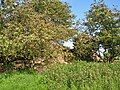
 Ruins of Trabboch Castle from the east |
||
| Creation time : | Early 14th century | |
| Castle type : | Niederungsburg (Tower House) | |
| Conservation status: | ruin | |
| Standing position : | Scottish nobility | |
| Construction: | Quarry stone | |
| Place: | Stair | |
| Geographical location | 55 ° 28 '6.2 " N , 4 ° 26' 26.9" W | |
| Height: | 94 m ASLTemplate: height / unknown reference | |
|
||

Trabboch Castle is the ruin of a lowland castle ( Tower House ) with L-shaped floor plan in the community Stair in the Scottish management unit East Ayrshire .
history
Baronate and Lairds

The Trabboch lands were first mentioned in a lease amount of 1303/1304 . King Robert the Bruce loaned the L-shaped castle to the Boyds of Kilmarnock in return for services they had rendered to him at the Battle of Bannockburn in 1314, as discovered in an undated charter in the Register of the Great Seal in which it says that King Robert I lent the "lands of Trebach" in Kyle-Regis to Robert Boyd . Paterson states that "Trebach Fortress" was forfeited to the Crown in 1469 after the Boyds fell out of favor in 1469, supposedly for use by the eldest sons of the Kings of Scotland. The Royal Commission on the Ancient and Historical Monuments in Scotland states that in 1451 the lands came into the hands of William, Earl of Douglas and later to the Boswells of Auchinleck . In the 17th century, the Chalmers von Gadgirth and the Reids von Barskimming held parts of the Trabboch Baronate . Love states that the Arthurs, Lords of Ochiltree , and the Campbells of Loudoun also owned Trabboch Castle.
As the caput of the Baronate Trabboch there was probably a Moot Hill , of which, however, no remains have been preserved. It is believed to have been on the site of what is now Lawhill Farm nearby. The related Trabboch mill stood on the Water of Coyle and was not powered by the waters of the lake. Campbell sees Trabboch Castle as the only remnant of a defensive line of castles that once stretched over Kyle Regis and also consisted of Stair Castle , Auchencloigh Castle , Drongan Castle and Drumsuie Castle .
Remains of the castle and tumulus
The remains of Trabboch Castle consisted of L-shaped wall remnants in 1954 with no visible traces of windows or doors that may have previously stood on a mound . The walls are 2.5 meters thick and about 3 meters high and are made of massive quarry stone masonry . To the northwest, the remains of the wall extend over a length of 9 meters, to the southwest to 12.5 meters. A wide, natural moat is visible on the west side, and a shallow, curved moat on the south side could have been part of the castle fortifications. The owner of the Trabboch Farm also had some finds . Much of the building blocks were used to build the nearby Trabboch Mains Farm . The ruins of the castle are now considered a Scheduled Monument .
Near the castle ruins, a grave was found below a burial mound , cut out of solid red sandstone and covered with a stone slab containing some artificial pearls and blackish dust.

Trabboch Castle grounds with earthworks

Castle ruins from the west

Details of the castle walls

Castle wall on the south side
Castle ruins from the southwest


James Boswell of Auchinleck is reported to have said: “I wish my father would buy Trabboch Mains , a beautiful farm which is now being offered for sale by Sir John Whiteford , as this was and is still the location of the Baronate Trabboch mansion can see the traces of the old house. "
Cartographic evidence
Gordon's map from 1636–1652 shows Trabboch Castle. Roy's 1747 map shows both "Trabog" [sic] and Lawhill. Moll's map from 1745 shows the castle. "Traboch Castle" [sic] is clearly marked on John Thomson's map from 1828.
Lake of Trabboch
The old lake of Trabboch was a body of water where swans, grouse and other water birds nested, and as part of the old Baronate Trabboch it was also a hunting and fishing ground for the laird. Trabboch Loch was a body of water that formed in the 19th century after the Drumdow mine was flooded .
Individual evidence
- ↑ James Paterson: History of the Counties of Ayr and Wigton . Volume 2. Part 2: Kyle . J. Stillie, Edinburgh 1863-1866. P. 17.
- ↑ a b Trabboch Castle . In: Canmore . Royal Commission on the Ancient and Historical Monuments in Scotland. Retrieved February 15, 2018.
- ^ Martin Coventry: Castles of the Clans . Goblinshead, Musselburgh 2010. ISBN 1-899874-36-4 . P. 54.
- ↑ James Paterson: History of the Counties of Ayr and Wigton . Volume 2. Part 2: Kyle . J. Stillie, Edinburgh 1863-1866. P. 634.
- ^ Dane Love: Ayrshire: Discovering a County . Fort Publishing, Ayr 2003. ISBN 0-9544461-1-9 . P. 202.
- ^ A b c John Smith: Prehistoric Man in Ayrshire . Elliot Stock, London 1895. p. 143.
- ↑ a b Thorbjørn Campbell: Ayrshire. A Historical Guide . Birlinn, Edinburgh 2003. ISBN 1-84158-267-0 . P. 252.
- ↑ Scheduled Monument - Entry . In: Historic Scotland .
- ↑ Michael C. Davis: The Castles and Mansions of Ayrshire . Spindrift Press, Ardrishaig 1991. p. 392.
- ↑ Robert Gordon: Cunigham [sic Cunningham] . National Library of Scotland. 1636-1652. Retrieved February 16, 2018.
- ^ Roy Military Survey of Scotland . In: Roy Military Survey . National Library of Scotland. 1747-1755. Retrieved February 16, 2018.
- ↑ Herman Moll: The South Part of the Shire of Air [i. e. Ayr , containing Kyle and Carrick] . National Library of Scotland. 1745. Retrieved February 16, 2018.
- ^ John Thomson: Northern Part of Ayrshire. Southern Part . National Library of Scotland. 1828. Retrieved February 16, 2018.
- ↑ James Conn: Aroon The Raws - a Memory of Trabboch . Francis Frith. March 19, 1980. Retrieved February 16, 2018.