
Translagorai
| Translagorai | |
|---|---|
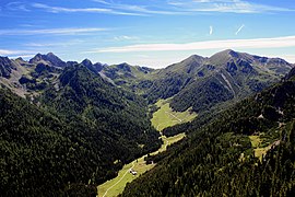
 Monte Cauriol in Val Sadole |
|
| Data | |
| length | approx. 80 km |
| location | Trentino , Italy |
| Starting point |
Panarotta 46 ° 3 ′ 0 ″ N , 11 ° 20 ′ 3.8 ″ E |
| Target point |
Passo Rolle 46 ° 17 ′ 47 ″ N , 11 ° 47 ′ 13 ″ O |
| Type | Long-distance hiking trail |
| The highest point | 2565 m |
| Lowest point | 1594 m |
| Level of difficulty | heavy |
| season | summer |
| Months | End of June to mid-September |
| particularities | Alpine high-altitude trail with many relics from the First World War |
The Translagorai is an alpine high- altitude hiking trail that leads in around 80 km and several daily stages through the Lagorai chain in Trentino .
general description
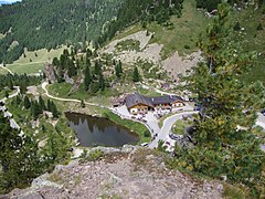
Translagorai is the ridge crossing of the Lagorai chain in its entire east-west orientation. The path is not specially signposted and runs through the Lagorai on the trail network maintained by the Trentiner Alpenverein (SAT). An inspection can take place in both directions. The starting and ending points are usually the Panarotta above Levico Terme in the Valsugana and the Passo Rolle, which connects the Fiemme Valley with the Primör . Other possible starting or ending points are the Passo Manghen and the Rifugio Sette Selle . The Panarotta - Passo Rolle route takes between five and six days. The Translagorai can be interrupted at any time. The Rifugio Cauriol , the Rifugio Refavaie in Vanoi or the Passo Manghen can be used as emergency exits, all of which can be reached by car and are on the route with the exception of the Rifugio Refavaie.
The difficulty with the ascent of the Translagorai, which is also one of the main attractions, is due to the few infrastructures that can be found along the route. With the Rifugio Sette Selle and the Rifugio Cauriol, there are only two managed refuges as stage destinations along the route. Depending on the stage planning, you can also spend the night at Passo Manghen and in the Rifugio Malga Conseria. Otherwise you have to get by with self-catering huts, usually simple bivouac huts or alpine pastures with bivouac facilities. This means that the appropriate equipment including food must be carried with you for several days. On the way, provisions can only be bought to a limited extent in the refuges or in the alpine pastures, if they are managed. There is enough drinking water along the route. After snowy winters, snow fields must always be expected on the north side. Due to the lack of shelters, you usually only meet a few hikers along the route. The relative isolation is certainly one of the attractions of the tour, but at the same time it is a risk factor that should not be underestimated.
Upper Val di Calamento
Forcella delle Sute

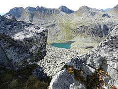
Lago Lagorai from the Forcella Vallon

Monte Ziolera
Passo Manghen
.jpg)


Stages
The route from west to east is shown in six stages. A total of about 5000 vertical meters are covered in the ascent and 4500 vertical meters in the descent.
| stage | begin | target | Walking time | Route |
|---|---|---|---|---|
| 1 day | Panarotta | Rifugio Sette Selle ⊙ | 7 h | Panarotta path 325, Mt. Fravort, M. Gronlait, Pizzo Alto, path 343, Cima Cavè, Rifugio Sette Selle |
| 2 day | Rifugio Sette Selle | Bivacco al Mangheneto ⊙ | 5 h | Rifugio Sette Selle, path 340, Passo Cagnon di Sopra, path 461, Passo Cadin, path 310, Bivacco al Mangheneto |
| 3rd day | Bivacco al Mangheneto | Malga Val Cion ⊙ | 5 h | Bivacco al Mangheneto, path 310, Passo Manghen, path 322, Forcella Ziolèra, Forcella Valsorda, path 318, Passo Val Cion, Malga Val Cion (one hour must be added to the managed Rifugio Malga Conseria) |
| 4th day | Malga Val Cion | Rifugio Cauriol ⊙ | 8 h | Malga Val Cion, Passo Val Cion, path 316, Forcella Lagorai, path 321, Forcella Pieroni, Forcella Litegosa, Passo Sadole, Rifugio Cauriol |
| 5th day | Rifugio Cauriol | Bivacco Paolo e Nicola ⊙ | 6 h | Rifugio Cauriol, path 349, Forcella Coldòse, Forcella Valmaggiore, Bivacco Paolo e Nicola |
| 6th day | Bivacco Paolo e Nicola | Passo role | 8 h | Bivacco Paolo e Nicola, path 349, Forcella di Cece, Forcella Valon, Bivacco Aldo Moro, Forcella Colbricon, Passo Colbricon, path 348, Malga Rolle |
literature
- Mario Corradini: Lagorai - Cima d'Asta. Guida dei Monti d'Italia . Club Alpino Italiano - Touring Club Italiano , Milan 2006, ISBN 88-365-3378-7 .
- Società degli Alpinisti Tridentini - Sezione del CAI - Commissione Sentieri: … per sentieri e luoghi. Sui monti del Trentino. 2 Lagorai, Cima d'Asta, Calisio, Monti di Cembra . Euroedit, Trento 2013, ISBN 978-88-86147-96-5 .
cards
- Compass hiking map 1: 25,000 Val Sugana – Cima d'Asta-Valle dei Mocheni No. 621 (western and central part)
- Compass hiking map 1: 25,000 Fiemme Valley / Val di Fiemme – Catena del Lagorai No. 618 (central and eastern part)
Individual evidence
- ↑ Translagorai, Natura, storia, solitudine. In: enrosadira.it. Retrieved July 19, 2019 (Italian).
- ^ Società degli Alpinisti Tridentini - Sezione del CAI - Commissione Sentieri: … per sentieri e luoghi. Sui monti del Trentino. 2 Lagorai, Cima d'Asta, Calisio, Monti di Cembra p. 289