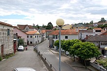
Treixedo
| Treixedo | ||||||
|---|---|---|---|---|---|---|
|
||||||
| Basic data | ||||||
| Region : | Centro | |||||
| Sub-region : | Dão-Lafoes | |||||
| District : | Viseu | |||||
| Concelho : | Santa Comba Dão | |||||
| Coordinates : | 40 ° 26 ′ N , 8 ° 6 ′ W | |||||
| Residents: | 993 (as of June 30, 2011) | |||||
| Surface: | 12.09 km² (as of January 1, 2010) | |||||
| Population density : | 82 inhabitants per km² | |||||
| Postal code : | 3440-548 | |||||
| politics | ||||||
| Mayor : | Domingos Costa | |||||
| Address of the municipal administration: | Junta de Freguesia de Treixedo Rua Outeiro de Cima 3440-548 Treixedo |
|||||
| Website: | treixedo.wix.com/treixedo | |||||
Treixedo is a municipality ( freguesia ) in the Portuguese district of Santa Comba Dão . It has a population of 993 (as of June 30, 2011).
history
Treixedo was first mentioned in 974. It received its first town charter in 1102, in the course of the resettlement efforts after the Reconquista and the destruction and displacement in the area. King Manuel I renewed the town charter in 1514, and Treixedo remained an independent district until it was dissolved and incorporated into the district of Santa Comba Dão in 1836.
Culture and sights
Among its architectural monuments are the church Igreja Matriz de Treixedo (also Igreja de Nossa Senhora da Assunção ) from the early 18th century, the 122-meter long metal railway bridge, and the remains of the pillory ( Pelourinho ) from the 16th century.
Web links
Individual evidence
- ↑ a b www.ine.pt - indicator resident population by place of residence and sex; Decennial in the database of the Instituto Nacional de Estatística
- ↑ Overview of code assignments from Freguesias on epp.eurostat.ec.europa.eu
- ↑ http://treixedo.wix.com/treixedo , accessed December 3, 2012
- ↑ www.monumentos.pt , accessed on December 3, 2012
- ↑ ditto
- ↑ ditto


