Tuja (river)
|
Tuja - Święta Tuga Tiege - Schwente |
||
|
Tuja at Nowy Dwór Gdański |
||
| Data | ||
| location | Poland | |
| River system | Vistula | |
| source | not far from the head of Danzig | |
| muzzle |
Szkarpawa ( Elbinger Weichsel ) coordinates: 54 ° 17 ′ 4 " N , 19 ° 8 ′ 20" E 54 ° 17 ′ 4 " N , 19 ° 8 ′ 20" E |
|
| Mouth height |
0.5 m npm
|
|
| length | 49.2 km | |
| Catchment area | 267.6 km² | |
| Small towns | Nowy Dwór Gdański , Nowy Staw | |
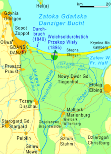
The Tuja (also Tuga, German Tiege ) is a 49.2 km long river in the Vistula Delta , which flows into the Szkarpawa ( Elbinger Vistula ) . In the past, only the lower reaches from Nowy Dwór Gdański ( Tiegenhof ) were called Tiege , until there the river was called Święta ( Schwente ).
River course
The Tuja or Święta has its source near the Danzig head and flows between the Vistula and Nogat in a north-northeastern direction. At Rybina ( Fischerbabke ) the Tuja flows into the Szkarpawa.
The catchment area of the river covers 267.6 km².
use
In the 19th century, the approximately 12 kilometer long basin was used by ships. In Tiegenhof there are still remnants of the granaries, quays and a drawbridge. 13 more kilometers of the Schwente were still navigable for barges from the sugar factory in Nowy Staw ( Neuteich ). These 25 kilometers can still be traveled with small pleasure craft today.
In addition, the river carried away the water from the deep Vistula Delta lifted by the dewatering mills.
Cities
Small towns along their route are:
- Nowy Dwór Gdański ( Tiegenhof )
- Nowy Staw ( Neuteich )
More places
In addition to the town of Tiegenhof, several villages and residential areas were named after the Tiege: Tiegenhagen (Tujce), Tiegenort (Tujsk) with Tiegenorterfeld, Tiege (Tuja), Tiegerfelde (Tujskie Pole) and Tiegerweide.
Web links
- Tuga (Tuja) i Święta (Polish, with photos)
Footnotes
- ^ Tuga (Tuja) i Święta
- ↑ Preussische Provinzial-Blätter , Volume 20. Königsberg 1838. P. 130.

