Tula (archaeological site)
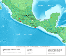
Tula is the modern, Hispanic form of the name of the place called in the Aztec Tōllān (translated: place of rushes). To distinguish it from other places that also bore this name (although less as a proper name, but more as an honorary designation) one said more precisely: Tōllān Xicocotitlān . The place was the cultural center of the Toltecs . The ruins are located 65 km northwest of today's Mexico City in the state of Hidalgo in the municipality of Tula de Allende and was inhabited between the 10th and 12th centuries AD. Appropriately, the name Tollan is used for the place in the historical, pre-Hispanic context, the name Tula for the ruins and the modern place Tula de Allende .
The town
The center of Tula forms a large zone that was mainly used for ceremonial purposes. It is dominated by a large open area, around which three porticoes are grouped. The smaller center of Tula Chico, north of the tourist zone, which was the older center of the city, is of further importance. Housing estates covered a wide area. It is therefore believed that more than 60,000 people lived in Tula in the 11th and 12th centuries. Parts of the housing estate to the west and south of the modern entrance to the archaeological zone have been exposed but not reconstructed.
Pyramid of Tlahuizcalpantecuhtli
The most famous building in this zone is the Morning Star Pyramid (also Temple of Quetzalcoatl , Temple of Tlahuizcalpantecuhtli or Temple B ). It is a truncated pyramid consisting of five pyramid levels arranged one above the other. On the east side, on the two lowest steps in long horizontal fields, the flat plastic decoration that originally presumably surrounds the entire pyramid is preserved (on the other sides only the pegs protruding from the wall, which gave the facade cladding support). The top (preserved) row shows an uninterrupted, south-facing procession of jaguars alternating with coyotes (the former with a collar and a raised tail). The bottom row contains clusters of two eagles feeding on bleeding hearts. In between, in deepened fields, the peculiar en-face image of a hybrid of human (face) and feather snake (oversized, forked tongue, feathers on the sides). It is believed that at least the jaguar procession is modeled on Teotihuacán, where there are similar rows of jaguars. Below this row is a slightly sloping surface with no decoration. Noteworthy are the clay pipes for draining off rainwater, which were attached to the sides of the pyramid below the decorative layer.
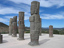
On the surface of the pyramid there are three types of stone monuments today: round pillar drums that belong to the raised bodies of the feathered snakes that carried the entrance. Behind four sculptural figures of Toltec warriors (4.5 m high), with their characteristic costume and armament, and finally square pillars with flat drawings of warriors. The modern line-up is hypothetically based on the warrior temple of Chichén Itzá . Most of the monuments were found in a deep ancient excavation at the back of the pyramid, which must have been a deliberate act of destruction. This extensive destruction is associated with “Aztec II” ceramics, which indicates the originator.
Because of the destruction, there is also no trace of an outer wall surrounding the assumed temple building. The monumental staircase on the south side of the pyramid is purely hypothetical in this form, only the imprint of the lowest step on the stucco floor of the vestibule and the imprint of the stair stringers were preserved.
Pyramid C
Diagonally across from the pyramid described above is the larger of the two temples, which has only been partially excavated so far. The floor plan is slightly different: the stairs on the west side do not run on the actual pyramid body, but on a structure in front of it, similar to the one found in Teotihuacán. The pyramid originally had five steps, which were probably decorated similarly to the sides of the Tlahuizcalpantecuhtli pyramid. Judging by parts of stone sculptures (in the museum of Tula), this temple building also had serpent columns at the entrance, and warrior figures as altants.
Porticoes
Column halls of different sizes are located on the north, east and south sides. What they have in common is that they have a single, double or triple row of columns facing the large plaza. Along the wall behind were low, stone benches, which were temporarily interrupted by higher and more protruding platforms, the sides of which were decorated with processions of warriors. Passages led from these columned halls to larger room complexes, which were only examined and reconstructed in detail on the north side of the plaza. Here, too, the reconstruction is problematic, quote from the excavator Jorge Acosta: "It is strange that during the excavation of 48 pillars [south of the Tlahuizcalpan pyramid] no traces of how the pillars were constructed were found".
Palacio Quemado
The so-called “Burnt Palace” because of its traces of fire is located west of the Tlahuizcalpantecuhtli pyramid. Behind the portico, a passage leads to a square room with a central impluvium . The traces visible in the ground indicate two rows of columns. Next to this room are two more, which could be entered from a corridor along the pyramid or from a pillared hall to the west. They are identical in floor plan. Behind it are smaller rooms. Below the Palacio , the existence of a large building from the Coyotlatelco phase (around 800) has been established, as well as one or two early post-classical constructions. The function of the Palacio was likely to have been a meeting place for the warrior societies. Since no stoves or sleeping places were found, an interpretation as a residential building is unlikely.
Ball courts
In the central area of Tula there are two large ball courts: one takes up almost the entire western side of the large courtyard, the other is located north a short distance from the Tlahuizcalpantecuhtli pyramid. They correspond to the late classical type with a low, slightly inclined reflective surface and vertical side wall (as in Xochicalco ). In ancient times, the side walls below the reflective surface were decorated with reliefs, of which only small remains have survived. The originally existing stone rings in the middle of the side walls are also not preserved; the places where they were fixed in the wall are visible. After the ball playgrounds were abandoned and destroyed, smaller structures were built in them, such as sweat baths in ball playground 2. The function of the niches on the side walls of the end faces has not been clarified.
El Corral
One and a half kilometers north of the entrance to the archaeological zone is a group in which residential buildings were examined. In this complex there is also the pyramid, which has a peculiar floor plan, a rectangular structure (from the back to the front), a wider, circular and a rectangular transverse structure that accommodates the stairs. The building has at least two construction phases, the older one, which consists of two stages, was reconstructed. The younger, much larger one is only preserved as a low wall remnant. On a small altar next to the stairs there were reliefs with crossed bones and skulls and other figures, they are now in the local museum.
Tula and Chichén Itzá
There is an undoubted resemblance to the buildings, the complex and the sculptural decorations of Chichén Itzá , the late Classical Maya city in Yucatan . The hypothetical Maya Toltecs were viewed as intermediaries . Some of the similarities are reinforced or even caused by the fact that Chichén Itzá was chosen as the model for the reconstruction of the heavily damaged building.
history
The Toltecs immigrated to central Mexico around two hundred years after the fall of Teotihuacán , where they found a power vacuum. In the 10th century, Tula rose to the dominant power in the region, probably because the city was able to bring the obsidian deposits previously exploited by Teotihuacán under control. Other important factors were its status as a major transport hub and high agricultural yields. At the height of power, Tula probably had around 30,000 inhabitants and was the leading center for obsidian processing. Ceramic finds also show that there were also cultural connections to eastern Mesoamerica ; even multicolored pottery from what is now Costa Rica was discovered. However, the city's prosperity did not last long, as the large residential areas were destroyed as early as the middle of the 11th century. When the ceremonial center was destroyed is still unclear, at least traces of fire were discovered and also traces of intentionally torn pyramids.
Individual evidence
- ↑ Alba Guadalupe Mastache, Robert H. Cobean: Tula. In: The Oxford Encyclopedia of Mesoamerican Cultures. Vol. 3. Oxford University Press, Oxford 2001, ISBN 0-19-510815-9 , p. 271.
- ^ Jorge R. Acosta: La cuarta y quinta temporada de exploraciones arqueológicas en Tula, Hgo. 1943-1944. In: Revista Mexicana de Estudios Antropológicos. 7 (1946), pp. 23-673, p. 40.
- ^ Augusto F. Molina Montes: Archaeological buildings: Restoration or misrepresentation. In: Elizabeth H. Boone (Ed.): Falsifications and misreconstruction of pre-columbian art . Dumbarton Oaks, Washington 1982, ISBN 0-88402-111-4 , pp. 125-141.
literature
- Hanns J. Prem : History of ancient America. Oldenbourg, Munich 1989, ISBN 3-486-53032-1 . (2nd revised edition 2007)
See also
Coordinates: 20 ° 3 '48.4 " N , 99 ° 20' 27.4" W.


