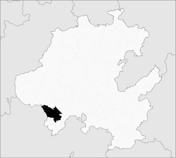
Municipio Tula de Allende
| Tula de Allende | ||
|---|---|---|

|
||
| Symbols | ||
|
||
| Basic data | ||
| Country | Mexico | |
| State | Hidalgo | |
| Seat | Tula de Allende | |
| surface | 337.1 km² | |
| Residents | 103,919 (2010) | |
| density | 308.3 inhabitants per km² | |
| founding | March 18, 1826 | |
| Website | tula.gob.mx | |
| INEGI no. | 13076 | |
| politics | ||
| Presidente municipal | Jaime Allende Gonzalez | |
| Tula de Allende Cathedral | ||
Coordinates: 20 ° 3 ′ N , 99 ° 21 ′ W
Tula de Allende is a municipality in the Mexican state of Hidalgo . The seat of the municipality is the Tula de Allende of the same name . The community had 103,919 inhabitants in 2010, its area is 337.1 km² .
geography
location
The municipality of Tula de Allende is located in the southwest of the state of Hidalgo, about 70 km north of Mexico City.
The municipality borders in the north on the municipalities Chapantongo , Tepetitlán and Tezontepec de Aldama , in the east on Tlaxcoapan , Atitalaquia and Atotonilco de Tula and in the south on Tepejí de Ocampo . In the west the municipality borders on the state of México .
Cities
The largest place in the municipality is its capital of the same name, two other places have over 10,000 inhabitants. In total there are over 70 localities in the area of the Municipio Tula de Allende.
| Cities | Residents |
| Tula de Allende | 28,577 |
| El Llano | 14,559 |
| San Marcos | 12,779 |
| local community | 103,919 |
Also in the municipality of Tula de Allende is the archaeological site of Tula .
Web links
- Enciclopedia de los Municipios y Delegaciones de México: Tula de Allende (Spanish)
- INEGI : Datos Geográficos: Tula de Allende (Spanish; PDF)

