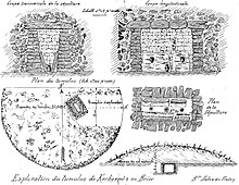
Kerbernez tumulus
The excavation of the tumulus of Kerbernez northwest of Kerbenez , a hamlet belonging to Briec in the Finistère department in Brittany in France , is described in the bulletin of the Archaeological Society of Finistere from 1892 by Maurice Halna du Fretay (1835-1901).
The excavated, round mound of earth, about 35 m in diameter and 5.5 m high, lay on a plateau about 3.0 km in diameter. The property is called "Goarem An Tuchen"; "Goarem" means stony ground and "Tuchenn" is a word that stands for hill in Cornouaille .
Under the mound, on the old surface, lay four concentric circles of large boulders, and next to the center was a stone mound . Beneath the cairn, about 6.0 m below the surface of the hill, was sunk into the ground, a rectangular dolmen of the type "Pierre sèche" (made of dry stone ) covered with four slates of slate . The long side walls recede upwards, so that the floor area is much narrower. In France, dolmen is the generic term for megalithic structures of all kinds (see: French nomenclature ). The short side walls, however, are vertical. In the chamber, large thin panels (two long and two short) are leaning against the wall on both sides. Remains of three urns were found at different heights in the filling floor between the plates . The outer urns are about 1.0 m away from the main urn located below. They are made from red, rather coarse, unevenly thick, unfired pottery. The very hard slate triangle above the main urn could be raw material for a spearhead . 25 flints were found in the chamber and in the mound, and more recent relics made of iron, flint and urns in the mound. The tumulus dates from around 4000 BC. From the Neolithic Age and is one of the earliest megalithic systems. This is indicated by the design and the access-free design.
See also
literature
- Pierre-Roland Giot, Jacques Briard : Protohistoire de la Bretagne . Ouest-France, Rennes 1979, ISBN 2-858820-89-9 , ( Université ).
- Jacques Briard: Mégalithes de Bretagne . Ouest-France, Rennes 1987, ISBN 2-7373-0119-X .
Coordinates: 48 ° 7 '20.3 " N , 4 ° 1' 58.8" W.
