Leisure lake Tuttenbrock
| Leisure lake Tuttenbrock | ||
|---|---|---|

|
||
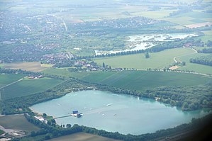
| The recreational lake Tuttenbrock, image from an airplane | ||
| Geographical location | Warendorf district , North Rhine-Westphalia | |
| Drain | Overflow to the Geißlerbach (→ Hellbach → Angel ) | |
| Places on the shore | Beckum | |
| Location close to the shore | Awls | |
| Data | ||
| Coordinates | 51 ° 46 '29 " N , 8 ° 1' 32" E | |
|
|
||
| Altitude above sea level | 110 m above sea level NHN | |
| surface | 19 ha | |
| length | 550 m | |
| width | 380 m | |
The recreational lake Tuttenbrock (or simply Tuttenbrocksee ) is a recultivated bathing lake near Beckum in the Warendorf district . It belongs to the Beckum lake landscape .
Location and description
The lake is in the east of the Roland district . To the north are the lakes Roland 1 and the remaining open pit of the Friedrichhorst quarry . There is a small island in the eastern part of the lake.
history
Like all lakes in the Beckum lake landscape, the Tuttenbrocksee was created from a former limestone quarry . After the economic use it was completely recultivated and handed over in 1993 as a 31 hectare recreational area . Today there are footpaths and cycle paths, sunbathing lawns, a water ski facility and other tourist offers on and around the lake .
Others
The water quality of the Tuttenbrocksee is marked as excellent .
See also
Individual evidence
- ↑ mapcoordinates.net. Find Google Maps coordinates easily. Retrieved June 14, 2015.
- ↑ a b c d Tuttenbrock leisure lake. Information for investors (PDF). Retrieved April 11, 2018.
- ↑ a b Tuttenbrock leisure lake. Sparkling pleasure in turquoise water. Website of the city of Beckum. Retrieved June 14, 2015.
- ↑ The Tuttenbrocksee in the database of seen.de . Retrieved June 14, 2015.
