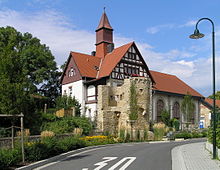
Uffhubtor
The Uffhubtor is one of the best preserved city gates of the former fortifications of Ober-Ingelheim .
Location and surroundings
The gate is on the southwestern city limits of Ober-Ingelheim near the castle church . In the immediate vicinity is the second Ober-Ingelheim electricity plant (today's name Old E-Werk). In 2008 a green area was laid out next to the gate.
Surname
Uffhub is derived from Aufhof due to the dialect. The street below the Uffhubtores bears the official name Aufhof. In the Middle Ages, it led to the noble homesteads in Stiegelgasse.
history
From construction to auction
The gate was built for the access from Mainz in the 14th century and is the youngest of the city fortifications. Up until the French Revolution, wine was still registered here for the collection of taxes by the winegrowers. The name is derived from this. With the city fortifications, the gate also lost its importance at the beginning of the 19th century and fell into ruin, except for the masonry. Around 1900 the gate was built by Franz Falk from Ingelheim (grandson of the politician Joh. Baptist Falk). auctioned to get it. In the 20th century, the gate came back into the possession of the city of Ingelheim am Rhein . Today the building is a listed building .
21st century, remodeling and redevelopment
Traffic passed through the gate until 2007, and since the construction of a bypass road it has been closed to traffic. In 2009 it was extensively renovated.
architecture
The once habitable gate, designed as a shell tower , originally had pointed towers, of which only the remains of the wooden gable have survived. It has a Gothic archway and is decorated with a round arch frieze. In addition, you will find the at gates typical machicolation . The battlements and the mortises of the gate leaves are still present .
In the Middle Ages, the city wall led from the gate directly to the castle church ; since the construction of the power station (1905) the city wall is no longer visible or has been demolished.
literature
- Karl Heinz Henn: The fortifications of Ober-Ingelheim. in: Contributions to Ingelheim History, Issue 36, 1987
Web links
Individual evidence
- ↑ Philipp Krämer. In: Ober-Ingelheim - A home book . Reprint 5, 2000, p. 19.
Coordinates: 49 ° 57 '41.9 " N , 8 ° 3' 50.7" E


