
Gongju
| Gongju | ||||
|---|---|---|---|---|
| Korean alphabet : | 공주시 | |||
| Chinese characters : | 公 州市 | |||
| Revised Romanization : | Gongju | |||
| McCune-Reischauer : | Kongchu | |||
| Basic data | ||||
| Province : | Chungcheongnam-do | |||
| Coordinates : | 36 ° 27 ' N , 127 ° 7' E | |||
| Residents: | 130,000 | |||
| Structure: | Si | |||
| map | ||||
|
||||


Gongju ( 공주시 ) is a city with a population of around 130,000 in the province of Chungcheongnam-do ( mittleren ) in the west of South Korea .
geography
Gongju is around 120 km south of Seoul and 50 km from the west coast. The Geumgang ( 금강 ) flows through the city and, coming from the east, bends in the city at a right angle to the southwest. The megacity Daejeon ( 대전 광역시 ) is only 25 km southeast of Gongju away.
Gongju is connected in terms of traffic via Expressway 25, which runs from north to south, and Expressway 30, which comes from the northwest and runs to the east . The Expressway 151 branches west of the center of Expressway 30 and connects to the southwest of the city to the west coast. The city does not have a direct train connection and it is not possible to transport goods by ship on the Geumgang.
To the southwest of the city is the Gyeryongsan National Park ( 계룡산 국립 공원 ).
history
The city of Gongju received its name in 940 AD under King Taejo (877–943) ( 태조 ), who founded the Goryeo Empire (918–1392) ( 고려 국 ) at the beginning of his reign in 918 and Gongju with administrative tasks in the kingdom provided.
The city gained importance as early as the 5th century after Baekje lost the war against Goguryeo in AD 475 and Baekje's capital Hanseong ( 한성 ) fell into the hands of the enemy. The newly appointed King Munju (? –477) ( 문주왕 ) moved the capital to Ungjin ( 웅진 ), today's Gongju, and reorganized the empire.
Under King Seong ( 성왕 ) the capital was moved to Sabi ( 사비 ), today's Buyeo ( 부여군 ). Ungjin was then used administratively to control the northern part of the kingdom. During the Silla Dynasty , the city underwent two more, but less significant, renaming, 686 in Ungcheon under King Shinmun and in 757 in Ungju under King Kyungdeok .
In 1895, Chungcheong Province was divided into three districts, with Gongju as Gongju-bu one of the largest districts in the country and administered 27 counties. But just one year later the system was abandoned and Gongju was assigned 37 districts in the center of southern Chungcheong. In 1932, the provincial administration for southern Chungcheong was moved from Gongju to Daejeon, 25 km away. 1986 the upgrade from a Eup , small town with more than 20,000 inhabitants, to Si , city with more than 50,000 inhabitants. This was accompanied by the division of the city into city and district. In 1995 this division was reversed and the city got its administrative status, which is still valid today.
Attractions

- The fortress Gongsanseong ( 공산성 ), on 4 July 2015 of UNESCO for World Heritage appointed.
- The Royal Tombs of Songsan-ri ( 송산리 ), declared a World Heritage Site by UNESCO on July 4th, 2015.
- The Gongju National Museum
- The traditional Korean there from Gongju
- Gyeryong-san pottery village ( 계룡산 )
- The temples of Magoksa ( 마곡사 ), Gapsa ( 갑사 ), Sinwonsa ( 신원사 ) and Donghaksa ( 동학사 )
- The Gyeryongsan National Park ( 계룡산 국립 공원 )
Photo gallery

Map of Gongju from 1872

Tourist card

View of the city and the walkway
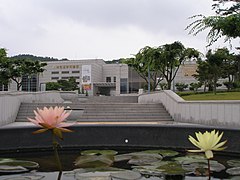
Gongju National Museum


See also
literature
- Republic of Korea (Ed.): Nomination of Baekje Historic Areas . For Inscription on the World Heritage List . Seoul 2015, ISBN 978-89-299-0345-9 (English, online [PDF; 323.0 MB ; accessed on September 20, 2015]).
Web links
- Homepage of the city of Gonju-si ( 공주시 ). Gongju City,accessed September 19, 2015(Korean).
- Gonju City website. Gongju City , accessed September 20, 2015 .
Individual evidence
- ↑ Klaus A. Dietsch: Gongju . In: South Korea . 1st edition. Trescher Verlag, Berlin 2013, ISBN 978-3-89794-244-8 , Central Korea, p. 269 .
- ↑ a b c History of Gongju . Gongju City , accessed September 20, 2015 .
- ^ New History of Korea . In: The Academy of Korean Studies (Ed.): Koren Studies Series No. 30 . Jemoodang , Paju-si 2005, ISBN 89-88095-85-5 , pp. 205 (English).
- ↑ Nomination of Baekje Historic Areas . Seoul 2015, p. 83 .