Ura (Barents Sea)
|
Ura Ура |
||
|
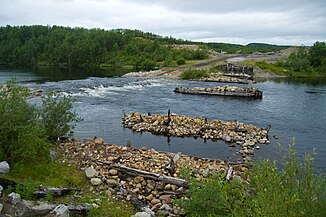
Destroyed bridge over the Ura |
||
| Data | ||
| Water code | RU : 02010000612101000000936 | |
| location | Murmansk Oblast ( Russia ) | |
| River system | Ura | |
| source | 40 km west of Murmansk 68 ° 58 ′ 48 ″ N , 32 ° 9 ′ 25 ″ E |
|
| muzzle | at Ura-Guba in the Ura-Bucht Coordinates: 69 ° 17 ′ 42 ″ N , 32 ° 51 ′ 0 ″ E 69 ° 17 ′ 42 ″ N , 32 ° 51 ′ 0 ″ E |
|
| Mouth height |
0 m
|
|
| length | 63 km | |
| Catchment area | 1030 km² | |
| Discharge at the Ura-Guba A Eo gauge : 1020 km² Location: 3 km above the mouth |
MQ 1935/1991 Mq 1935/1991 |
14.5 m³ / s 14.2 l / (s km²) |
| Flowing lakes | Kilpjawr | |
| Navigable | No | |
The Ura ( Russian Ура ) is a 63 km long river in the northwest of the Murmansk Oblast in Russia .
The river has its source about 40 km west of Murmansk , flows in a northerly direction, flows through Lake Kilpjawr and finally flows into the southern end of Ura Bay and the Barents Sea at Ura-Guba . The catchment area covers 1030 km², the mean discharge at the mouth 14.5 m³ / s.
