Va'a-o-Fonoti
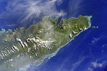
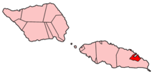
Va'a-o-Fonoti is a political district (itūmālō) of the island state of Samoa on the northeast coast of the island of Upolu . In 2001 the district had 1,666 inhabitants, making the district the smallest in the country in terms of population.
geography
The district covers 38 km² and consists of the area around Fagaloa Bay with nine villages and a small exclave on the coast, about 10 km further north-west, the village Faleāpuna (582 inhabitants). The district has places with particularly valuable natural and cultural treasures. Va'a-o-Fonoti is completely surrounded inland by the larger district of Atua . The capital of Va'a-o-Fonoti is Samamea .
Faleapuna is located on Falefa Bay , into which one of the Samoa rivers flows, the Page River . Inland, shortly after leaving the Atua district, this forms the Falefa Falls ( ⊙ ). The main part of Va'a-o-Fonoti extends between Utuloa Point and Cape Tulaele ( ⊙ ). The places on the coast are: Musumusu , Salimu , Taelefaga , Maasina , Lona , and Samamea in Fagaloa Bay, as well as Uafato in Uafato Bay , to which the Fagaloa Bay – Uafato Tiavea Conservation Zone connects to the east . The residents of Uafato began a project in the 1990s to save their forests from being deforested. The area has built a reputation for wood carving and traditional handicrafts in Samoa over the past few decades.
history
The name literally means "Longboat of Fonoti" and was used for the courage of the boat crews in this area during armed conflicts. Va'a-o-Fonoti was formally established and received its name in the 16th century when Fonoti, the victorious title contender for the junior title of Tui Atua (Tui Atua Faasavali), granted the residents of this part of Atua privileges for their valor in the War of Succession gave. Later Tui Atua Faasavali lived in different places on the "back and tail" (back and tail) of Atua.
The chief title in the district is Mata'utia .
Individual evidence
- ↑ UNESCO World Heritage. November 13, 2009: Fagaloa Bay - Uafato Tiavea Conservation Zone.
- ↑ geonames.org .
- ↑ geonames.org .
- ↑ The making of modern Samoa by Malama Meleisea : 132.
Coordinates: 13 ° 57 ′ S , 171 ° 32 ′ W


