
Savai'i
| Savai'i | ||
|---|---|---|
 |
||
| Waters | Pacific Ocean | |
| Archipelago | Samoa Islands | |
| Geographical location | 13 ° 35 ′ S , 172 ° 25 ′ W | |
|
||
| length | 70 km | |
| width | 40 km | |
| surface | 1 694 km² | |
| Highest elevation |
Silisili 1858 m |
|
| Residents | 44,402 (2011) 26 inhabitants / km² |
|
| main place | Salelologa | |
 |
||

Savaiʻi is the largest and westernmost island of the Independent State of Samoa (Engl.) Or Samoan: Malo Saʻoloto Tutoʻatasi o Sāmoa , Sāmoa for short in the Pacific . It is much less populated than the second main island, Upolu . About 44,402 (2011) people live on Savaiʻi; largest city is Salelologa at the eastern end of the island.
geography

Savai'i, the largest of the Samoan islands , is about 40 km wide, 70 km long and reaches an area of 1694 km² . The south coast of Savaiʻi is rugged and rocky. The north coast is less rough, there is a natural anchorage at Matautu . The land rises from the coasts, extinct volcanoes rise in a cone shape either individually or in groups. The highest crater is the Mua near the village of A'opo.
The highest mountain on the island is the Silisili , with 1858 m also the highest mountain in the Samoa Islands. At the end of October and November 1902, volcanic eruptions and earthquakes took place again in the then unpopulated center of the island . On August 4, 1905, the Matavanu broke out and remained active until November 1911. Today you can see the mighty, frozen lava flows . Also worth seeing are the Taga blowholes , lava tubes in which sea water burns and shoots to the surface.
The island owes its origin to the Samoa hotspot , a fixed upflow of hot rock material ( mantle plume ) from the earth's mantle. This leads to the formation of shield volcanoes on the Pacific plate, which is slowly shifting above it . Savaiʻi is considered to be the largest shield volcano in the South Pacific.
The nature shows plane trees , palm trees , lemon and breadfruit trees .
history

Savaiʻi was discovered for Europe during Jean-François de La Pérouse's expedition from 1785 to 1788. From March 1, 1900, Savaiʻi became part of the German Colonial Empire and incorporated into the administration of German Samoa . In August 1914, Franz Pfeil was appointed bailiff to administer the island.
economy
The inhabitants of the islands grow bananas , copra and cocoa for export.
tourism
Tourism is of little importance today. In and around Savaiʻi you can hike, sail and dive. From time to time, cruise ships anchor off the north coast at Fagamalo and take their passengers ashore for excursions inland with motorized rubber dinghies.
In the south of the island is the Pulemelei Mound , the oldest structure in Polynesia - an approx. 60 × 65 m large and 12 m high basalt pyramid. It was scientifically examined in 2002 and dated to an age of 600 to 900 years.
gallery
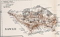
Map of the island around 1910

Samoan girl, 1896

The village of Matautu on the north coast, 1902

Fale tele , traditional house in Lelepa, 2009
_Map_of_Sawaii_Island,_Samoa.jpg)


Individual evidence
- ↑ 2011 Samoa Census: Population and Housing Census. Analytical Report. Government of Samoa. Retrieved March 4, 2015
- ^ Hotspot Lesson: Samoan Hotspot. Scripps Institution of Oceanography, accessed January 1, 2018 .
Web links
- Pictures and short description ( memento from December 23, 2010 in the Internet Archive )
- Research report on excavations at the basalt pyramid of Pulemelei (English)