Rose Atoll
| Rose Atoll | ||
|---|---|---|
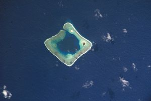
| NASA image of the Rose Atoll | ||
| Waters | Pacific Ocean | |
| archipelago | Samoa Islands | |
| Geographical location | 14 ° 33 ′ S , 168 ° 9 ′ W | |
|
|
||
| Number of islands | 2 | |
| Main island | Rose Island | |
| Land area | 21.4 ha | |
| Lagoon area | 2.46 km² | |
| total area | 6.6 km² | |
| Residents | uninhabited | |
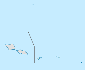
| Map of the Rose Atoll | ||
The Rose Atoll , also Rose Island , is an uninhabited, almost square-shaped atoll in the Pacific Ocean that belongs to the territory of American Samoas . The land area is 0.214 km², and the total area of the atoll with lagoon is around 5 km². In the northeast of the coral reef there are two islands, the larger Rose Island in the east and the vegetation-free Sand Island in the north.
The Rose Atoll is the southernmost territory in the United States .
The first documented sighting of a European was by Louis de Freycinet in 1819, who named the atoll Île de Rose after his wife Rose de Freycinet . In 1824 the atoll was sighted again by an expedition led by Otto von Kotzebue , who named it after his first lieutenant Kordinkow .
The two islets have been an important bird resting place and breeding ground for the green sea turtle since 1973 as the Rose Atoll National Wildlife Refuge . In 2009, the Rose Atoll Marine National Monument was also designated. The US Fish and Wildlife Service and the government of American Samoa are responsible for maintaining the two protected areas .
Possible area reduction of the Rose Atoll Marine National Monument by President Trump
On April 26, 2017, President Trump, with Executive Order 13792, instructed the United States Department of the Interior to review the area of 27 National Monuments, which were designated after January 1, 1996 and are at least 100,000 hectares in size. On August 24, Home Secretary Ryan Zinke presented the final report on Executive Order 13792 . The final report called for land reductions in the Bears Ears National Monument , Cascade-Siskiyou National Monument , Gold Butte National Monument , Grand Staircase-Escalante National Monument , Pacific Remote Islands Marine National Monument, and Rose Atoll Marine National Monument. In addition, more traditional human uses such as grazing, logging, coal mining and commercial fishing are to be allowed within the protected areas for all National Monuments examined. Zinke justified this by saying that presidents had gone too far in recent decades to restrict commercial activities in the National Monuments.
Individual evidence
- ↑ United States Census Bureau
- ^ US Fish and Wildlife Service
- ↑ Executive Order 13792 of April 26, 2017 Review of Designations Under the Antiquities Act
- ↑ Final Report Summarizing findings of the Review of Designations Under the Antiquities Act
- ↑ Shrink at least 4 national monuments and modify a half-dozen others, Zinke tells Trump Washington Post, September 17, 2017


