Aunu'u
| Aunu'u | ||
|---|---|---|
| Aunu'u | ||
| Waters | Pacific Ocean | |
| Archipelago | Samoa Islands | |
| Geographical location | 14 ° 17 ′ 0 ″ S , 170 ° 33 ′ 0 ″ W | |
|
|
||
| length | 1.5 km | |
| width | 1.2 km | |
| surface | 1.517 km² | |
| Highest elevation | Fogatia Hill 84 m |
|
| Residents | 436 (2010) 287 inhabitants / km² |
|
| main place | Aunu'u | |
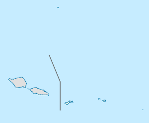
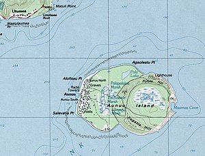
| Map of the island of Aunuʻu | ||
Aunu'u is a small island of volcanic origin, which geographically belongs to the Samoa Islands and politically to American Samoa .
geography
The area of the island is about 1.52 km². Almost all of the island's 436 inhabitants live in the only place Aunuʻu on the west coast.
The island is only separated from its large neighboring island of Tutuila by an approximately 1 km wide waterway and is located opposite the village of Utumea. The closest point is Matuli Point a little east of Utumea.
The east is formed almost exclusively by the caldera of an extinct volcano. The two peaks of the island are on the crater rim. Pofala Hill at 75 meters to the north is the location of the lighthouse . In the south lies Fogatia Hill, which according to some sources is even higher than Pofala Hill.
environment
Large amounts of fresh water have accumulated inside the volcanic crater, creating a unique flora and fauna. Because of the high diversity of plants and animals in the Faimulivai Marsh in the center of the caldera, the area of the caldera was placed under nature protection.
The entire island has been a National Natural Landmark since 1972 . In the nature park you can find, among other things, the Pacific black duck , purple chickens and water chestnuts .
administration
Administratively, Aunuʻu is one of the six villages in SaʻOle County , which is part of the Eastern District of American Samoa.
Web links
- Flora and fauna of the island ( Memento from September 29, 2007 in the Internet Archive ) (English)


