
Aiga-i-le-Tai
| Aiga-i-le-Tai | |
|---|---|
| Basic data | |
| Country | Samoa |
| Capital | Mulifanua |
| Residents | 4508 (2001) |
| ISO 3166-2 | WS-AL |
 |
|
Coordinates: 13 ° 52 ′ S , 172 ° 4 ′ W

Aiga-i-le-Tai is a political district (itūmālō; electoral district) of Samoa . It consists of an area at the western end of Upolu , as well as the islets of Manono , Apolima and the uninhabited Nuʻulopa in the Apolima Strait between the two islands of Upolu and Savaiʻi .
Surname
The name "'aiga i le tai" means "family by the sea" in Samoan .
geography
The district includes the westernmost part of Upolu Island, as well as the islets of Manono, Apolima and the uninhabited Nu'ulopa in Apolima Strait. It surrounds an exclave of the itūmālō Aʻana , namely the village of Satuimalufilufi ( ⊙ ) in the northwest. The terrain rises very gently. In the extreme south of the district, Mount Olomanu reaches a height of 204 m ( ⊙ ).
The center of the district is now Mulifanua , where the Inter-Island Ferry Terminal is located, which ensures the ferry connection between Savaiʻi and Upolu. The area of Faleolo Airport in the A'ana area is directly connected to the east .
With an area of only 27 km², Aiga-i-le-Tai is the smallest electoral district in Samoa. The district had 4,500 inhabitants in 2001. In terms of population, only Vaʻa-o-Fonoti is smaller. Originally, Manono Island was the actual center of the district. This has only changed since the ferry terminal was completed.
Mulifanua Ferry Terminal
Today the Ferry Terminal at Mulifanua is the second most important port on the island next to the port of the capital Apia . The port is the main connection to Savai'i. A regular passenger and vehicle ferry runs seven days a week between Mulifanua and Salelologa on Savai'i.
Chief title
Historically, the nautical-strategic location of Manono and Apolima played an important role in the political battles between the individual clans.
One of the most important chief titles (fa'amatai) in the district is Leiataua . The district is also an important base for the Sa Malietoa . Manono plays an important role in the election of the Malietoa chiefs as the village of Malie has to listen to Manono's advice.
archeology
In 1973, during expansion work on the Mulifanua pier, prehistoric fragments of decorated Lapita ceramics were discovered. Scientists from New Zealand estimate these pieces to be 3,000 years old. The Lapita site had sunk in the sea. Only at this point in Samoa were decorated Lapita shards found
gallery
- Aiga-i-le-Tai

Visitors to Nu'ulopa .

Apolima .

Faleo'o beach fale on Manono island.
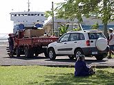
Cars at the Mulifanua ferry terminal .


Individual evidence
- ↑ Samoa Bureau of Statistics: Population and Housing Census Report 2006. ( Memento of July 21, 2011 in the Internet Archive ) July 2008.
- ↑ ws.geoview.info .
- ↑ geonames.org Satuimalufilufi.
- ↑ [1] Mount Olomanu.
- ↑ Pacific Islands Legal Information Institute: Samoa Territorial Constituencies Act 1963. ( Memento of the original from June 5, 2011 in the Internet Archive ) Info: The archive link was automatically inserted and not yet checked. Please check the original and archive link according to the instructions and then remove this notice. December 15, 2009.
- ^ HM Leach: Journal of the Polynesian Society: New Information For The Ferry Berth Site, Mulifanua, Western Samoa . In: Roger C. Green & Helen M. Leach, Journal of the Polynesian Society, Vol. 98, No. 3, 1989: 319-330.
- ^ William R. Dickinson: Temper sands in prehistoric Oceanian pottery: geotectonics, sedimentology, petrography, provenance . Geological Society of America 2006: 34.

Upolu : Tuamasaga | A'ana | Aiga-i-le-Tai | Atua | Va'a-o-Fonoti
Savaiʻi : Faʻasaleleaga | Gagaʻemauga | Gagaʻifomauga | Vaisigano | Satupaʻitea | Palauli