Valles Caldera
| Valles Caldera | ||
|---|---|---|
|
Valles Caldera from an image from NASA's Landsat satellite |
||
| height | 3430 m | |
| location | New Mexico , USA | |
| Mountains | Jemez Mountains | |
| Coordinates | 35 ° 52 ′ 0 ″ N , 106 ° 29 ′ 0 ″ W | |
|
|
||
| Type | Caldera | |
| Last eruption | 50,000 to 60,000 years ago | |
| Normal way | Hiking trails | |
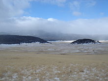
The Valles Caldera is located in Sandoval County in the state of New Mexico in the United States of America and is a caldera up to 22 km in diameter near Los Alamos .
The Valles Caldera was formed during two large eruptions about 1.7 and 1.2 million years ago, which had an ejection quantity of about 600 km³, which is why it is counted among the super volcanoes . The deposits from these two eruptions are known as Bandelier tuff rock. The steeply sloping crater walls of the caldera are up to 300 meters high.
The most recent eruptions within the caldera occurred about 60,000-50,000 years ago. These formed the El Cajete cone, the terrain formation of the Battleship Rock, the Banco Bonito rhyolite and the VC-1 rhyolite, which have formed within the caldera. At 3,430 meters above sea level, Redondo Peak is the highest elevation within the caldera complex, which has a variety of thermal springs and fumaroles . Not far from the caldera is an area with low seismic activity.
The Valles Caldera is located in a historically volcanically active zone of the Pleistocene and Holocene , which also includes the Toledo Caldera , the Cerros del Rio volcanic field (this formed the eastern Pajarito Plateau ) and the Caja del Rio Plateau.
Nowadays the Valles Caldera is in the area of the Bandelier National Monument , which is also used as a backdrop for westerns .
Web links
swell
- Valles-Caldera in the Global Volcanism Program of the Smithsonian Institution (English)
- The geological history of the Valles Caldera
- Bandelier National Monument on the US National Park Service website


