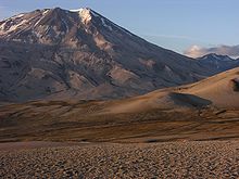
Valley of Ten Thousand Smokes


The Valley of Ten Thousand Smokes (dt. Valley of Ten Thousand Columns of smoke ) is a volcanically active region in Alaska ( USA ) on the Alaska Peninsula .
Origin, meaning
In June 1912 - after previous earthquakes - the Novarupta volcano erupted in the Katmai region, Alaska. It was one of the most powerful volcanic explosions in historical time, comparable to that of Santorini , Krakatau or Tambora . Geologists disagree as to whether the Novarupta explosion was not the largest volcanic eruption in the 20th century; what is certain is that it was the largest on the American continent. It was around ten times as powerful as the Mount St. Helens explosion in 1980.
The eruption covered about 65 km² of land with volcanic ash and other pyroclastic production products; the volcanic deposits reached heights of up to 200 m. The ash rain also fell in nearby Kodiak and even in Vancouver ; Kodiak reports that lit lanterns could no longer be seen within two meters. It is estimated that 30 km³ of ash was ejected in about 60 hours. In contrast to the eruptions of Krakatau or Tambora, which claimed many thousands of lives, - as far as is known - no people were harmed during the eruption in the Katmai area: the area was and is practically uninhabited.
After the eruption, a caldera and - in a neighboring valley - a myriad of fumaroles and small chimneys formed. The caldera later filled with rhyolite magma (a so-called lava dome ). In the neighboring valley, which was previously unnamed, hundreds of chimneys are said to have been 100 m high, some even up to 300 m high. The fumaroles are still active today and emit hot gases and water vapor - which is what gave the valley its name. The valley is about 20 km long and 3 to 9 km wide and is considered a tourist attraction in Katmai National Park . The only road in the national park leads into the valley from Brooks Camp on Naknek Lake .
Web links
- Valley of Ten Thousand Smokes in the Geographic Names Information System of the United States Geological Survey
- Further information and pictures
- USGS page with map
Coordinates: 58 ° 19 ′ 0 ″ N , 155 ° 14 ′ 0 ″ W.
