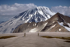
Mount Griggs
| Mount Griggs | ||
|---|---|---|
|
View from the northwest (from Mount Katmai ) (July 1990) |
||
| height | 2317 m | |
| location | Alaska Peninsula ( USA ) | |
| Mountains | Aleutian chain | |
| Coordinates | 58 ° 21 '11 " N , 155 ° 5' 37" W | |
|
|
||
| Type | Stratovolcano | |
| Last eruption | 1790 BC Chr. | |
The Mount Griggs is a 2,317 meter-high stratovolcano of the Aleutian Range on the Alaska Peninsula . It is located in Katmai National Park on the northeastern edge of the Valley of Ten Thousand Smokes and within sight of Mount Katmai .
Although there are no historical records of eruptions , active fumaroles in the crater and the upper southwest flank are evidence of volcanic activity. The roar of these steam exit points can partly still be heard on the valley floor . The slopes of the volcano are covered by pyroclastic material , which was erupted by Novarupta in 1912 .
The volcano is named after Robert Fiske Griggs (1881–1962), a botanist whose research after the 1912 eruption led to the establishment of Katmai National Park by President Woodrow Wilson .
Web links
- Mount Griggs in the Global Volcanism Program of the Smithsonian Institution (English)
- Description of Mount Griggs (Alaska Volcano Observatory )


