
Vladař
| Vladař | ||
|---|---|---|
 View from the southwest of the Vladař with Kolešov and Vladořice |
||
| height | 693 m | |
| location | Czech Republic | |
| Coordinates | 50 ° 4 '48 " N , 13 ° 12' 56" E | |
|
||
| Type | Table Mountain | |

The Vladař (German Wladarsch , also Wladarz ) is a 693 m high mountain in the Czech Republic . The Table Mountain is four kilometers southeast of the town Žlutice in Teplá highlands .
geography
The summit plateau, surrounded by large stone walls, has the shape of a tooth. There is a heavily silted pond on the Vladař. The summit consists of meadows and shrub vegetation and individual groups of trees and is criss-crossed by a network of footpaths.
A view is only possible at individual points, as there is a high beech and oak mixed forest on the slopes.
Záhořice ( Sahor ) is located on the north-western slope and Vladořice ( Wladarz ) estate is located on the southern slope . The Nevděk rises to the west .
history
Already at the time of the Celtic settlement there was a fortress on the mountain, see: Oppidum Vladař .
During the Hussite Wars , the Battle of Vladař took place on the mountain in mid-November 1421 , in which Jan Žižka's army entrenched itself with wagon castles on the summit and thus successfully resisted the three days of attacking Catholic troops from Pilsen .
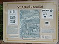
Plan of the summit on a display board

Silting pond on the Vladař

Evening view from Verušice over Žlutice to the Vladař


