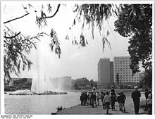
Front Gotthard pond
| Front Gotthard pond | |||||||||
|---|---|---|---|---|---|---|---|---|---|
| View from the northeast bank | |||||||||
|
|||||||||
|
|
|||||||||
| Coordinates | 51 ° 21 '9 " N , 11 ° 59' 31" E | ||||||||
| Data on the structure | |||||||||
| Construction time: | 1483 | ||||||||
| Data on the reservoir | |||||||||
| Water surface | 5.8 hectares | ||||||||
The Vordere Gotthardteich in Merseburg in Saxony-Anhalt is a listed reservoir .
In the local register of monuments , the pond and the rear Gotthard pond are listed as the Gotthard pond under registration number 094 20173 as a monument .
The inflow takes place through the Geisel over the rear Gotthard pond from the west, the outflow over the Klia to the northeast. The maximum length and width are about 270 meters with an area of 5.8 hectares .
The fish include eel, perch, pike, crucian carp, carp, roach, rudd and tench.
history
The first documentary mention of a damming of the hostage in this area dates back to the 12th century. In 1483, according to other information in 1480, the pond was created in its present form as a fish pond , including an old quarry . The fish pond was set up under Bishop Thilo von Trotha by the monks of the monastery on Gotthardstrasse, who then ran a fish farm. In around 1700, promenades were laid out in the vicinity of the pond and a ducal fishery was founded. In the 19th and 20th centuries, a landscape park was created that included both the pond and the surrounding area.
The Gotthard pond was originally stretched over more than two kilometers in a south-westerly direction from Merseburg to Zscherben , but most of its western parts have not been preserved. In 1846 a railway embankment was built for the Thuringian Railway , which separated the larger eastern Vorderen Gotthardteich from the smaller western Hinteren Gotthardteich.
In 1907 the factory owner Adolf C. Blancke donated a fountain for the middle of the lake. The fountain system was renovated in 1969 and 1984, but was taken out of service in 1999. In 2007 there was a renewal. The fountain reaches a height of 8 to 17 meters.
Originally there was an outflow from the hostage in the southeast corner of the pond, but it was filled in during the GDR era . Since then, only the Klia in the northeast has existed as a drain.
literature
- Falko Grubitzsch, Marina Meincke-Floßfeder: List of monuments Saxony-Anhalt, Volume 6.1, Merseburg-Querfurt district (I), Merseburg district. fly head publisher Halle, 2000, ISBN 3-910147-66-6 , page 146.
- Jürgen Jankofsky , Small Guide to Merseburg , 1992, page 45.


