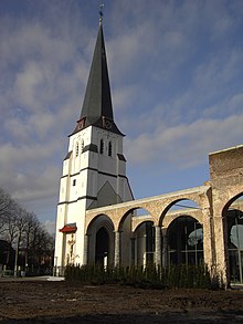
Waarschoot
| Waarschoot | ||
|---|---|---|

|

|
|
|
|
||
| State : |
|
|
| Region : | Flanders | |
| Province : | East Flanders | |
| District : | Ghent | |
| Municipality : | Lievegem | |
| Coordinates : | 51 ° 9 ′ N , 3 ° 36 ′ E | |
| Area : | 21.91 km² | |
| Residents: | 7,967 pop. | |
| Population density: | 364 inhabitants per km² | |
| Post Code: | 9950 | |
| Prefix: | 09 | |
Waarschoot is a district of the Belgian municipality of Lievegem in the Flanders region with 7967 inhabitants (as of January 1, 2018). Waarschoot was an independent municipality until January 1, 2019.
Eeklo is 4 kilometers to the northwest, Ghent 14 km to the southeast, Bruges 27 km to the northwest, Antwerp 55 km to the east and Brussels about 63 km to the southeast.
The next motorway exits are at Nevele and Aalter on the A10 / E 40 . The place has a regional train station on the Gent – Eeklo railway line; others are in Aalter and Landegem . National express trains also stop in Ghent.
In Ostend and Antwerp is regional airports and near the capital Brussels is an international airport.
In the area of Eeklo (name means "Eichenlohe"), Waarschoot and Zomergem is the "provincial domain" Het Leen .

